Banyo geodata
Banyo (Queensland) is a section of populated place; located in Australia in Australia/Brisbane (GMT+10) time zone. With population of 5,717 people, there are 1283 cities with bigger population in this country. Compared to other cities in Australia, 84% of cities are located further ↓South; 94.2% of cities are located further ←West and 93.8% of cities have higher elevation than Banyo. Note1


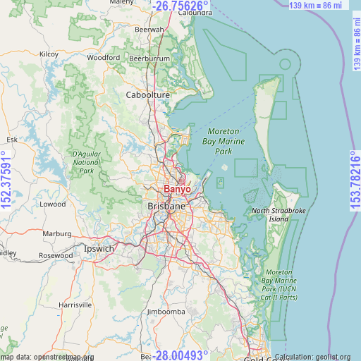
Banyo GPS coordinates[2]
27° 22' 56.496" South, 153° 4' 44.508" East
| Map corner | latitude | longitude |
|---|---|---|
| Upper-left | -26.75626°, | 152.37591° |
| Center: | -27.38236°, | 153.07903° |
| Lower-right: | -28.00493°, | 153.78216° |
| Map W x H: | 138.8×138.8 km | = 86.2×86.2mi |
| max Lat: | -10.58257° ⇑16% North |
| Banyo: | -27.38236° |
| min Lat: | ⇓84% South -43.31423° |
| min Long | Banyo | max Long |
| 113.53327° | 153.07903° | 153.61246° |
| W 94.2%⇐ | ⇒5.8% E |
Elevation
Elevation of Banyo is 7 m = 23 ft, and this is 115 m = 377 ft below average elevation for this country.
| Max E: |
1715 m = 5627 ft | 93.8% |
| Avg. | 122 m = 400 ft | |
| Banyo | 7 m = 23 ft | |
Min E: |
-2 m = -7 ft | 6.2% |
See also: Australia elevation on elevation.city.
Geographical zone
Banyo is located in South temperate zone (between Tropic of Capricorn and the Antarctic Circle). Distance of this Southern Tropic circle is 438.7 km =272.6 mi to North.| Distance of | km | miles | from Banyo |
|---|---|---|---|
| Equator | 3044.6 | 1891.8 | to North |
| Tropic Capricorn | 438.7 | 272.6 | to North |
| Antarctic Circle | 4356.5 | 2707 | to South |
| South Pole | 6962.4 | 4326.2 | to South |


Nearby cities:
15 places around Banyo: (largest is in red/bold)
• Ascot
5.8 km =3.6 mi,  200°
200°
• Boondall
3.7 km =2.3 mi,  331°
331°
• Chermside
4.8 km =3 mi,  266°
266°
• Clayfield
4.6 km =2.9 mi,  206°
206°
• Geebung
3.3 km =2.1 mi,  289°
289°
• Hendra
4 km =2.5 mi,  192°
192°
• Kalinga
4.1 km =2.5 mi,  222°
222°
• Kedron
5.4 km =3.4 mi,  244°
244°
• Nudgee
1.6 km =1 mi,  20°
20°
• Nundah
2.8 km =1.7 mi, 217°
• Taigum
5.6 km =3.5 mi,  322°
322°
• Virginia
1.2 km =0.7 mi,  264°
264°
• Wavell Heights
3.4 km =2.1 mi,  248°
248°
• Wooloowin
5.8 km =3.6 mi, 219°
• Zillmere
4.5 km =2.8 mi,  310°
310°
Sources, notices
• [Note1] Compared only with cities in Australia existing in our database
• [Src1] Map data: © OpenStreetMap contributors (CC-BY-SA)
• [Src2] Other city data from geonames.org with taken over terms of usage.
• [Src3] Geographical zone / Annual Mean Temperature by Robert A. Rohde @ Wikipedia
