Hendra geodata
Hendra (Queensland) is a section of populated place; located in Australia in Australia/Brisbane (GMT+10) time zone. With population of 4,620 people, there are 1592 cities with bigger population in this country. Compared to other cities in Australia, 83.5% of cities are located further ↓South; 93.9% of cities are located further ←West and 91.8% of cities have higher elevation than Hendra. Note1


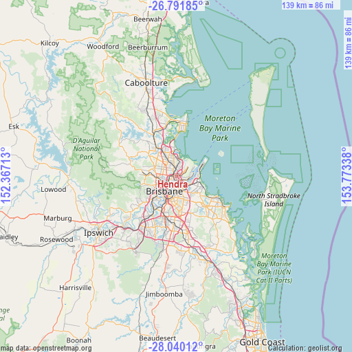
Hendra GPS coordinates[2]
27° 25' 3.9" South, 153° 4' 12.9" East
| Map corner | latitude | longitude |
|---|---|---|
| Upper-left | -26.79185°, | 152.36713° |
| Center: | -27.41775°, | 153.07025° |
| Lower-right: | -28.04012°, | 153.77338° |
| Map W x H: | 138.8×138.8 km | = 86.2×86.2mi |
| max Lat: | -10.58257° ⇑16.5% North |
| Hendra: | -27.41775° |
| min Lat: | ⇓83.5% South -43.31423° |
| min Long | Hendra | max Long |
| 113.53327° | 153.07025° | 153.61246° |
| W 93.9%⇐ | ⇒6.1% E |
Elevation
Elevation of Hendra is 8 m = 26 ft, and this is 114 m = 374 ft below average elevation for this country.
| Max E: |
1715 m = 5627 ft | 91.8% |
| Avg. | 122 m = 400 ft | |
| Hendra | 8 m = 26 ft | |
Min E: |
-2 m = -7 ft | 8.2% |
See also: Australia elevation on elevation.city.
Geographical zone
Hendra is located in South temperate zone (between Tropic of Capricorn and the Antarctic Circle). Distance of this Southern Tropic circle is 442.6 km =275 mi to North.| Distance of | km | miles | from Hendra |
|---|---|---|---|
| Equator | 3048.6 | 1894.3 | to North |
| Tropic Capricorn | 442.6 | 275 | to North |
| Antarctic Circle | 4352.6 | 2704.6 | to South |
| South Pole | 6958.5 | 4323.8 | to South |


Nearby cities:
15 places around Hendra: (largest is in red/bold)
• Ascot
2 km =1.2 mi,  218°
218°
• Balmoral
4 km =2.5 mi,  184°
184°
• Banyo
4 km =2.5 mi,  12°
12°
• Bowen Hills
4.3 km =2.7 mi,  228°
228°
• Bulimba
3.8 km =2.4 mi,  199°
199°
• Clayfield
1.2 km =0.7 mi,  263°
263°
• Gordon Park
4.4 km =2.7 mi,  268°
268°
• Hamilton
2.5 km =1.6 mi, 197°
• Kalinga
2.1 km =1.3 mi,  295°
295°
• Kedron
4.3 km =2.7 mi,  292°
292°
• Lutwyche
3.7 km =2.3 mi, 261°
• Nundah
1.9 km =1.2 mi,  333°
333°
• Virginia
3.8 km =2.4 mi,  354°
354°
• Wavell Heights
3.5 km =2.2 mi,  319°
319°
• Wooloowin
2.8 km =1.7 mi, 259°
Sources, notices
• [Note1] Compared only with cities in Australia existing in our database
• [Src1] Map data: © OpenStreetMap contributors (CC-BY-SA)
• [Src2] Other city data from geonames.org with taken over terms of usage.
• [Src3] Geographical zone / Annual Mean Temperature by Robert A. Rohde @ Wikipedia
