Parkside geodata
Parkside (South Australia) is a populated place; located in Australia in Australia/Adelaide (GMT+10.5) time zone. With population of 4,698 people, there are 1568 cities with bigger population in this country. Compared to other cities in Australia, 69.7% of cities are located further ↑North; 81% of cities are located further →East and 55% of cities have lower elevation than Parkside. Note1


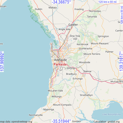
Parkside GPS coordinates[2]
34° 56' 42.432" South, 138° 36' 46.944" East
| Map corner | latitude | longitude |
|---|---|---|
| Upper-left | -34.36675°, | 137.90992° |
| Center: | -34.94512°, | 138.61304° |
| Lower-right: | -35.51944°, | 139.31617° |
| Map W x H: | 128.2×128.2 km | = 79.7×79.7mi |
| max Lat: | -10.58257° ⇑69.7% North |
| Parkside: | -34.94512° |
| min Lat: | ⇓30.3% South -43.31423° |
| min Long | Parkside | max Long |
| 113.53327° | 138.61304° | 153.61246° |
| W 19%⇐ | ⇒81% E |
Elevation
Elevation of Parkside is 53 m = 174 ft, and this is 69 m = 226 ft below average elevation for this country.
| Max E: |
1715 m = 5627 ft | 45% |
| Avg. | 122 m = 400 ft | |
| Parkside | 53 m = 174 ft | |
Min E: |
-2 m = -7 ft | 55% |
See also: Australia elevation on elevation.city.
Geographical zone
Parkside is located in South temperate zone (between Tropic of Capricorn and the Antarctic Circle). Distance of this Southern Tropic circle is 1279.6 km =795.1 mi to North.| Distance of | km | miles | from Parkside |
|---|---|---|---|
| Equator | 3885.5 | 2414.3 | to North |
| Tropic Capricorn | 1279.6 | 795.1 | to North |
| Antarctic Circle | 3515.6 | 2184.5 | to South |
| South Pole | 6121.5 | 3803.7 | to South |


Nearby cities:
15 places around Parkside: (largest is in red/bold)
• Adelaide
2.3 km =1.4 mi,  324°
324°
• Adelaide city centre
2 km =1.2 mi,  334°
334°
• Dulwich
1.6 km =1 mi,  53°
53°
• Eastwood
0.9 km =0.6 mi,  68°
68°
• Frewville
1.6 km =1 mi,  99°
99°
• Fullarton
1.6 km =1 mi,  114°
114°
• Glenside
1.9 km =1.2 mi,  82°
82°
• Goodwood
2 km =1.2 mi,  251°
251°
• Highgate
2 km =1.2 mi,  156°
156°
• Hyde Park
1.5 km =0.9 mi,  225°
225°
• Malvern
1.6 km =1 mi,  181°
181°
• Rose Park
2.1 km =1.3 mi,  40°
40°
• Unley
1.3 km =0.8 mi, 245°
• Unley Park
2.1 km =1.3 mi,  192°
192°
• Wayville
2 km =1.2 mi,  271°
271°
Sources, notices
• [Note1] Compared only with cities in Australia existing in our database
• [Src1] Map data: © OpenStreetMap contributors (CC-BY-SA)
• [Src2] Other city data from geonames.org with taken over terms of usage.
• [Src3] Geographical zone / Annual Mean Temperature by Robert A. Rohde @ Wikipedia
