Dulwich geodata
Dulwich (South Australia) is a section of populated place; located in Australia in Australia/Adelaide (GMT+10.5) time zone. With population of 1,650 people, there are 3137 cities with bigger population in this country. Compared to other cities in Australia, 69.5% of cities are located further ↑North; 80.4% of cities are located further →East and 60.7% of cities have lower elevation than Dulwich. Note1


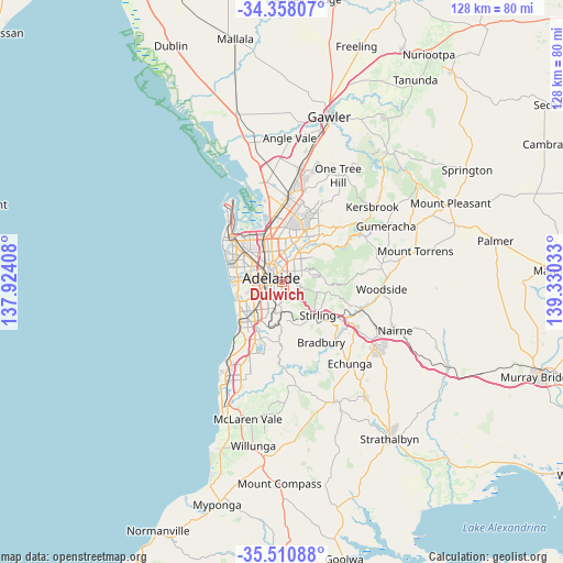
Dulwich GPS coordinates[2]
34° 56' 11.4" South, 138° 37' 37.92" East
| Map corner | latitude | longitude |
|---|---|---|
| Upper-left | -34.35807°, | 137.92408° |
| Center: | -34.9365°, | 138.6272° |
| Lower-right: | -35.51088°, | 139.33033° |
| Map W x H: | 128.2×128.2 km | = 79.7×79.7mi |
| max Lat: | -10.58257° ⇑69.5% North |
| Dulwich: | -34.9365° |
| min Lat: | ⇓30.5% South -43.31423° |
| min Long | Dulwich | max Long |
| 113.53327° | 138.6272° | 153.61246° |
| W 19.6%⇐ | ⇒80.4% E |
Elevation
Elevation of Dulwich is 66 m = 217 ft, and this is 56 m = 184 ft below average elevation for this country.
| Max E: |
1715 m = 5627 ft | 39.3% |
| Avg. | 122 m = 400 ft | |
| Dulwich | 66 m = 217 ft | |
Min E: |
-2 m = -7 ft | 60.7% |
See also: Australia elevation on elevation.city.
Geographical zone
Dulwich is located in South temperate zone (between Tropic of Capricorn and the Antarctic Circle). Distance of this Southern Tropic circle is 1278.7 km =794.5 mi to North.| Distance of | km | miles | from Dulwich |
|---|---|---|---|
| Equator | 3884.6 | 2413.8 | to North |
| Tropic Capricorn | 1278.7 | 794.5 | to North |
| Antarctic Circle | 3516.6 | 2185.1 | to South |
| South Pole | 6122.5 | 3804.3 | to South |


Nearby cities:
15 places around Dulwich: (largest is in red/bold)
• Adelaide city centre
2.3 km =1.4 mi,  291°
291°
• Eastwood
0.8 km =0.5 mi,  217°
217°
• Frewville
1.3 km =0.8 mi,  165°
165°
• Fullarton
1.6 km =1 mi, 174°
• Glenside
0.9 km =0.6 mi,  139°
139°
• Glenunga
1.8 km =1.1 mi,  146°
146°
• Heathpool
1.8 km =1.1 mi,  72°
72°
• Kent Town
1.8 km =1.1 mi,  338°
338°
• Linden Park
2 km =1.2 mi,  112°
112°
• Marryatville
1.9 km =1.2 mi,  62°
62°
• Norwood
1 km =0.6 mi,  6°
6°
• Parkside
1.6 km =1 mi,  233°
233°
• Rose Park
0.7 km =0.4 mi, 8°
• Toorak Gardens
0.9 km =0.6 mi,  77°
77°
• Tusmore
2.1 km =1.3 mi,  97°
97°
Sources, notices
• [Note1] Compared only with cities in Australia existing in our database
• [Src1] Map data: © OpenStreetMap contributors (CC-BY-SA)
• [Src2] Other city data from geonames.org with taken over terms of usage.
• [Src3] Geographical zone / Annual Mean Temperature by Robert A. Rohde @ Wikipedia
