Kinka Beach geodata
Kinka Beach (Queensland) is a populated place; located in Australia in Australia/Brisbane (GMT+10) time zone. With population of 881 people, there are 4000 cities with bigger population in this country. Compared to other cities in Australia, 92% of cities are located further ↓South; 62.4% of cities are located further ←West and 86.8% of cities have higher elevation than Kinka Beach. Note1


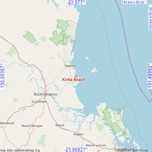
Kinka Beach GPS coordinates[2]
23° 13' 28.92" South, 150° 47' 48.444" East
| Map corner | latitude | longitude |
|---|---|---|
| Upper-left | -22.577°, | 150.09367° |
| Center: | -23.2247°, | 150.79679° |
| Lower-right: | -23.86927°, | 151.49992° |
| Map W x H: | 143.7×143.7 km | = 89.3×89.3mi |
| max Lat: | -10.58257° ⇑8% North |
| Kinka Beach: | -23.2247° |
| min Lat: | ⇓92% South -43.31423° |
| min Long | Kinka Beach | max Long |
| 113.53327° | 150.79679° | 153.61246° |
| W 62.4%⇐ | ⇒37.6% E |
Elevation
Elevation of Kinka Beach is 11 m = 36 ft, and this is 111 m = 364 ft below average elevation for this country.
| Max E: |
1715 m = 5627 ft | 86.8% |
| Avg. | 122 m = 400 ft | |
| Kinka Beach | 11 m = 36 ft | |
Min E: |
-2 m = -7 ft | 13.2% |
See also: Australia elevation on elevation.city.
Geographical zone
Kinka Beach is located in South Torrid zone (between Equator and Tropic of Capricorn). Distance of this Southern Tropic circle is 23.6 km =14.7 mi to South.| Distance of | km | miles | from Kinka Beach |
|---|---|---|---|
| Equator | 2582.3 | 1604.6 | to North |
| Tropic Capricorn | 23.6 | 14.7 | to South |
| Antarctic Circle | 4818.8 | 2994.3 | to South |
| South Pole | 7424.7 | 4613.5 | to South |


Nearby cities:
15 places around Kinka Beach: (largest is in red/bold)
• Barlows Hill
14.1 km =8.8 mi,  337°
337°
• Barmaryee
13 km =8.1 mi,  321°
321°
• Bondoola
13.3 km =8.3 mi,  299°
299°
• Cawarral
14.1 km =8.8 mi,  250°
250°
• Cooee Bay
9.7 km =6 mi, 337°
• Emu Park
4.7 km =2.9 mi,  139°
139°
• Lammermoor
8 km =5 mi,  332°
332°
• Mulambin
4.2 km =2.6 mi,  349°
349°
• Rosslyn
6.8 km =4.2 mi, 343°
• Tanby
4.9 km =3 mi,  258°
258°
• Taranganba
10.1 km =6.3 mi, 332°
• Taroomball
7.9 km =4.9 mi, 316°
• Yeppoon
12.1 km =7.5 mi, 333°
• Yeppoon city centre
12.3 km =7.6 mi, 329°
• Zilzie
7.1 km =4.4 mi,  178°
178°
Sources, notices
• [Note1] Compared only with cities in Australia existing in our database
• [Src1] Map data: © OpenStreetMap contributors (CC-BY-SA)
• [Src2] Other city data from geonames.org with taken over terms of usage.
• [Src3] Geographical zone / Annual Mean Temperature by Robert A. Rohde @ Wikipedia
