Docklands geodata
Docklands (Victoria) is a section of populated place; located in Australia in Australia/Melbourne (GMT+11) time zone. With population of 12,486 people, there are 381 cities with bigger population in this country. Compared to other cities in Australia, 87.9% of cities are located further ↑North; 67.2% of cities are located further →East and 85% of cities have higher elevation than Docklands. Note1


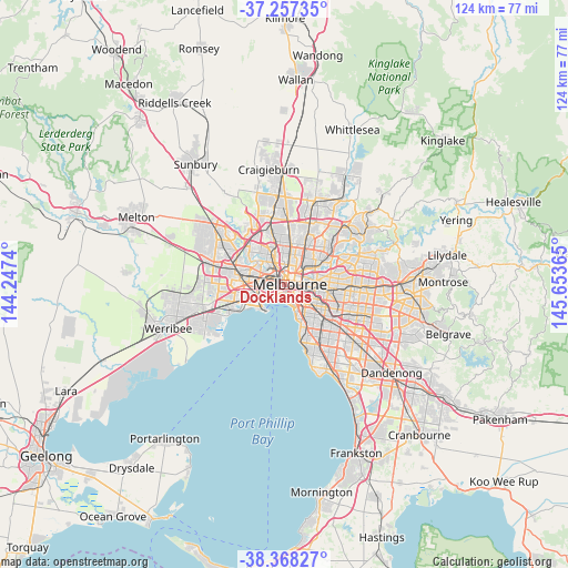
Docklands GPS coordinates[2]
37° 48' 53.64" South, 144° 57' 1.872" East
| Map corner | latitude | longitude |
|---|---|---|
| Upper-left | -37.25735°, | 144.2474° |
| Center: | -37.8149°, | 144.95052° |
| Lower-right: | -38.36827°, | 145.65365° |
| Map W x H: | 123.5×123.5 km | = 76.7×76.7mi |
| max Lat: | -10.58257° ⇑87.9% North |
| Docklands: | -37.8149° |
| min Lat: | ⇓12.1% South -43.31423° |
| min Long | Docklands | max Long |
| 113.53327° | 144.95052° | 153.61246° |
| W 32.8%⇐ | ⇒67.2% E |
Elevation
Elevation of Docklands is 12 m = 39 ft, and this is 110 m = 361 ft below average elevation for this country.
| Max E: |
1715 m = 5627 ft | 85% |
| Avg. | 122 m = 400 ft | |
| Docklands | 12 m = 39 ft | |
Min E: |
-2 m = -7 ft | 15% |
See also: Australia elevation on elevation.city.
Geographical zone
Docklands is located in South temperate zone (between Tropic of Capricorn and the Antarctic Circle). Distance of this Southern Tropic circle is 1598.7 km =993.4 mi to North.| Distance of | km | miles | from Docklands |
|---|---|---|---|
| Equator | 4204.6 | 2612.6 | to North |
| Tropic Capricorn | 1598.7 | 993.4 | to North |
| Antarctic Circle | 3196.6 | 1986.3 | to South |
| South Pole | 5802.4 | 3605.4 | to South |


Nearby cities:
15 places around Docklands: (largest is in red/bold)
• Albert Park
2.9 km =1.8 mi,  177°
177°
• Carlton
2.2 km =1.4 mi,  40°
40°
• Carlton North
3.4 km =2.1 mi,  30°
30°
• East Melbourne
3.3 km =2.1 mi,  93°
93°
• Fitzroy
3.1 km =1.9 mi,  53°
53°
• Flemington
3.5 km =2.2 mi,  328°
328°
• Kensington
3.1 km =1.9 mi, 326°
• Melbourne
1.1 km =0.7 mi,  84°
84°
• Melbourne City Centre
1.4 km =0.9 mi, 90°
• North Melbourne
1.9 km =1.2 mi,  345°
345°
• Port Melbourne
2.8 km =1.7 mi,  194°
194°
• South Melbourne
2.5 km =1.6 mi,  145°
145°
• South Wharf
1.2 km =0.7 mi,  172°
172°
• Southbank
1.5 km =0.9 mi,  125°
125°
• West Melbourne
0.5 km =0.3 mi,  355°
355°
Sources, notices
• [Note1] Compared only with cities in Australia existing in our database
• [Src1] Map data: © OpenStreetMap contributors (CC-BY-SA)
• [Src2] Other city data from geonames.org with taken over terms of usage.
• [Src3] Geographical zone / Annual Mean Temperature by Robert A. Rohde @ Wikipedia
