Canterbury geodata
Canterbury (Victoria) is a section of populated place; located in Australia in Australia/Melbourne (GMT+11) time zone. With population of 7,926 people, there are 840 cities with bigger population in this country. Compared to other cities in Australia, 88.4% of cities are located further ↑North; 64.7% of cities are located further →East and 65.9% of cities have lower elevation than Canterbury. Note1


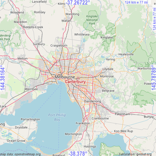
Canterbury GPS coordinates[2]
37° 49' 28.92" South, 145° 5' 5.136" East
| Map corner | latitude | longitude |
|---|---|---|
| Upper-left | -37.26722°, | 144.38164° |
| Center: | -37.8247°, | 145.08476° |
| Lower-right: | -38.378°, | 145.78789° |
| Map W x H: | 123.5×123.5 km | = 76.7×76.7mi |
| max Lat: | -10.58257° ⇑88.4% North |
| Canterbury: | -37.8247° |
| min Lat: | ⇓11.6% South -43.31423° |
| min Long | Canterbury | max Long |
| 113.53327° | 145.08476° | 153.61246° |
| W 35.3%⇐ | ⇒64.7% E |
Elevation
Elevation of Canterbury is 83 m = 272 ft, and this is 39 m = 128 ft below average elevation for this country.
| Max E: |
1715 m = 5627 ft | 34.1% |
| Avg. | 122 m = 400 ft | |
| Canterbury | 83 m = 272 ft | |
Min E: |
-2 m = -7 ft | 65.9% |
See also: Australia elevation on elevation.city.
Geographical zone
Canterbury is located in South temperate zone (between Tropic of Capricorn and the Antarctic Circle). Distance of this Southern Tropic circle is 1599.8 km =994.1 mi to North.| Distance of | km | miles | from Canterbury |
|---|---|---|---|
| Equator | 4205.7 | 2613.3 | to North |
| Tropic Capricorn | 1599.8 | 994.1 | to North |
| Antarctic Circle | 3195.5 | 1985.6 | to South |
| South Pole | 5801.3 | 3604.8 | to South |


Nearby cities:
15 places around Canterbury: (largest is in red/bold)
• Balwyn
1.8 km =1.1 mi,  343°
343°
• Balwyn North
3.8 km =2.4 mi,  11°
11°
• Box Hill
3.6 km =2.2 mi,  79°
79°
• Box Hill North
4.4 km =2.7 mi,  56°
56°
• Box Hill South
3.3 km =2.1 mi,  104°
104°
• Burwood
4.1 km =2.5 mi,  132°
132°
• Camberwell
2.4 km =1.5 mi,  214°
214°
• Glenferrie
3.2 km =2 mi,  252°
252°
• Hawthorn
4.3 km =2.7 mi,  277°
277°
• Hawthorn East
3.4 km =2.1 mi,  269°
269°
• Hawthorn South
4.3 km =2.7 mi,  257°
257°
• Kew East
4.1 km =2.5 mi,  317°
317°
• Mont Albert
2.2 km =1.4 mi,  69°
69°
• Mont Albert North
3.4 km =2.1 mi,  37°
37°
• Surrey Hills
1.6 km =1 mi, 56°
Sources, notices
• [Note1] Compared only with cities in Australia existing in our database
• [Src1] Map data: © OpenStreetMap contributors (CC-BY-SA)
• [Src2] Other city data from geonames.org with taken over terms of usage.
• [Src3] Geographical zone / Annual Mean Temperature by Robert A. Rohde @ Wikipedia
