Labrador geodata
Labrador (Queensland) is a section of populated place; located in Australia in Australia/Brisbane (GMT+10) time zone. With population of 18,326 people, there are 190 cities with bigger population in this country. Compared to other cities in Australia, 76.4% of cities are located further ↓South; 98.6% of cities are located further ←West and 95.5% of cities have higher elevation than Labrador. Note1


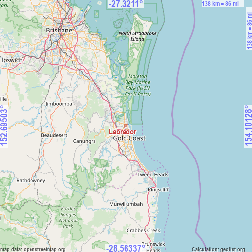
Labrador GPS coordinates[2]
27° 56' 38.472" South, 153° 23' 53.34" East
| Map corner | latitude | longitude |
|---|---|---|
| Upper-left | -27.3211°, | 152.69503° |
| Center: | -27.94402°, | 153.39815° |
| Lower-right: | -28.56337°, | 154.10128° |
| Map W x H: | 138.1×138.1 km | = 85.8×85.8mi |
| max Lat: | -10.58257° ⇑23.6% North |
| Labrador: | -27.94402° |
| min Lat: | ⇓76.4% South -43.31423° |
| min Long | Labrador | max Long |
| 113.53327° | 153.39815° | 153.61246° |
| W 98.6%⇐ | ⇒1.4% E |
Elevation
Elevation of Labrador is 6 m = 20 ft, and this is 116 m = 381 ft below average elevation for this country.
| Max E: |
1715 m = 5627 ft | 95.5% |
| Avg. | 122 m = 400 ft | |
| Labrador | 6 m = 20 ft | |
Min E: |
-2 m = -7 ft | 4.5% |
See also: Australia elevation on elevation.city.
Geographical zone
Labrador is located in South temperate zone (between Tropic of Capricorn and the Antarctic Circle). Distance of this Southern Tropic circle is 501.2 km =311.4 mi to North.| Distance of | km | miles | from Labrador |
|---|---|---|---|
| Equator | 3107.1 | 1930.7 | to North |
| Tropic Capricorn | 501.2 | 311.4 | to North |
| Antarctic Circle | 4294.1 | 2668.2 | to South |
| South Pole | 6900 | 4287.5 | to South |


Nearby cities:
15 places around Labrador: (largest is in red/bold)
• Arundel
3.5 km =2.2 mi,  281°
281°
• Ashmore
5.4 km =3.4 mi,  203°
203°
• Biggera Waters
1.3 km =0.8 mi,  8°
8°
• Coombabah
4.6 km =2.9 mi,  324°
324°
• Gaven
6.4 km =4 mi,  257°
257°
• Gold Coast
7 km =4.3 mi,  152°
152°
• Helensvale
7 km =4.3 mi,  294°
294°
• Hollywell
4.8 km =3 mi,  357°
357°
• Main Beach
4.8 km =3 mi,  144°
144°
• Molendinar
5 km =3.1 mi,  227°
227°
• Paradise Point
6.4 km =4 mi, 355°
• Parkwood
3.6 km =2.2 mi,  251°
251°
• Runaway Bay
3.4 km =2.1 mi, 359°
• Southport
2.6 km =1.6 mi,  180°
180°
• Surfers Paradise
7.2 km =4.5 mi, 154°
Sources, notices
• [Note1] Compared only with cities in Australia existing in our database
• [Src1] Map data: © OpenStreetMap contributors (CC-BY-SA)
• [Src2] Other city data from geonames.org with taken over terms of usage.
• [Src3] Geographical zone / Annual Mean Temperature by Robert A. Rohde @ Wikipedia
