Gaven geodata
Gaven (Queensland) is a section of populated place; located in Australia in Australia/Brisbane (GMT+10) time zone. With population of 1,549 people, there are 3240 cities with bigger population in this country. Compared to other cities in Australia, 76.3% of cities are located further ↓South; 97.9% of cities are located further ←West and 58.4% of cities have higher elevation than Gaven. Note1


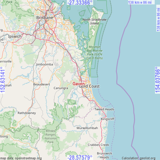
Gaven GPS coordinates[2]
27° 57' 23.436" South, 153° 20' 4.308" East
| Map corner | latitude | longitude |
|---|---|---|
| Upper-left | -27.33366°, | 152.63141° |
| Center: | -27.95651°, | 153.33453° |
| Lower-right: | -28.57579°, | 154.03766° |
| Map W x H: | 138.1×138.1 km | = 85.8×85.8mi |
| max Lat: | -10.58257° ⇑23.7% North |
| Gaven: | -27.95651° |
| min Lat: | ⇓76.3% South -43.31423° |
| min Long | Gaven | max Long |
| 113.53327° | 153.33453° | 153.61246° |
| W 97.9%⇐ | ⇒2.1% E |
Elevation
Elevation of Gaven is 34 m = 112 ft, and this is 88 m = 289 ft below average elevation for this country.
| Max E: |
1715 m = 5627 ft | 58.4% |
| Avg. | 122 m = 400 ft | |
| Gaven | 34 m = 112 ft | |
Min E: |
-2 m = -7 ft | 41.6% |
See also: Australia elevation on elevation.city.
Geographical zone
Gaven is located in South temperate zone (between Tropic of Capricorn and the Antarctic Circle). Distance of this Southern Tropic circle is 502.6 km =312.3 mi to North.| Distance of | km | miles | from Gaven |
|---|---|---|---|
| Equator | 3108.5 | 1931.5 | to North |
| Tropic Capricorn | 502.6 | 312.3 | to North |
| Antarctic Circle | 4292.7 | 2667.4 | to South |
| South Pole | 6898.6 | 4286.6 | to South |


Nearby cities:
15 places around Gaven: (largest is in red/bold)
• Arundel
3.5 km =2.2 mi,  53°
53°
• Ashmore
5.5 km =3.4 mi,  131°
131°
• Benowa
7.6 km =4.7 mi,  138°
138°
• Biggera Waters
7 km =4.3 mi,  67°
67°
• Coombabah
6.2 km =3.9 mi,  35°
35°
• Helensvale
4.3 km =2.7 mi,  357°
357°
• Highland Park
6.4 km =4 mi,  181°
181°
• Labrador
6.4 km =4 mi,  77°
77°
• Maudsland
6.7 km =4.2 mi,  276°
276°
• Molendinar
3.2 km =2 mi, 127°
• Mount Nathan
6.2 km =3.9 mi,  261°
261°
• Nerang
3.7 km =2.3 mi, 177°
• Pacific Pines
2.7 km =1.7 mi,  312°
312°
• Parkwood
2.8 km =1.7 mi,  85°
85°
• Southport
6.3 km =3.9 mi,  100°
100°
Sources, notices
• [Note1] Compared only with cities in Australia existing in our database
• [Src1] Map data: © OpenStreetMap contributors (CC-BY-SA)
• [Src2] Other city data from geonames.org with taken over terms of usage.
• [Src3] Geographical zone / Annual Mean Temperature by Robert A. Rohde @ Wikipedia
