Mossy Point geodata
Mossy Point (New South Wales) is a populated place; located in Australia in Australia/Sydney (GMT+11) time zone. With population of 524 people, there are 4801 cities with bigger population in this country. Compared to other cities in Australia, 78% of cities are located further ↑North; 57.5% of cities are located further ←West and 64.8% of cities have higher elevation than Mossy Point. Note1


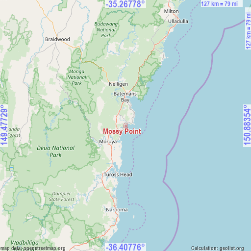
Mossy Point GPS coordinates[2]
35° 50' 23.352" South, 150° 10' 49.476" East
| Map corner | latitude | longitude |
|---|---|---|
| Upper-left | -35.26778°, | 149.47729° |
| Center: | -35.83982°, | 150.18041° |
| Lower-right: | -36.40776°, | 150.88354° |
| Map W x H: | 126.8×126.8 km | = 78.8×78.8mi |
| max Lat: | -10.58257° ⇑78% North |
| Mossy Point: | -35.83982° |
| min Lat: | ⇓22% South -43.31423° |
| min Long | Mossy Point | max Long |
| 113.53327° | 150.18041° | 153.61246° |
| W 57.5%⇐ | ⇒42.5% E |
Elevation
Elevation of Mossy Point is 27 m = 89 ft, and this is 95 m = 312 ft below average elevation for this country.
| Max E: |
1715 m = 5627 ft | 64.8% |
| Avg. | 122 m = 400 ft | |
| Mossy Point | 27 m = 89 ft | |
Min E: |
-2 m = -7 ft | 35.2% |
See also: Australia elevation on elevation.city.
Geographical zone
Mossy Point is located in South temperate zone (between Tropic of Capricorn and the Antarctic Circle). Distance of this Southern Tropic circle is 1379.1 km =856.9 mi to North.| Distance of | km | miles | from Mossy Point |
|---|---|---|---|
| Equator | 3985 | 2476.2 | to North |
| Tropic Capricorn | 1379.1 | 856.9 | to North |
| Antarctic Circle | 3416.2 | 2122.7 | to South |
| South Pole | 6022 | 3741.9 | to South |


Nearby cities:
15 places around Mossy Point: (largest is in red/bold)
• Batehaven
11.5 km =7.1 mi,  8°
8°
• Batemans Bay
14.8 km =9.2 mi,  358°
358°
• Broulee
1.8 km =1.1 mi,  199°
199°
• Catalina
12.2 km =7.6 mi,  1°
1°
• Denhams Beach
10.3 km =6.4 mi,  15°
15°
• Lilli Pilli
8.3 km =5.2 mi,  31°
31°
• Long Beach
15.7 km =9.8 mi, 21°
• Malua Bay
6.7 km =4.2 mi,  40°
40°
• Moruya
12 km =7.5 mi,  227°
227°
• Moruya Heads
9 km =5.6 mi, 195°
• North Batemans Bay
17.1 km =10.6 mi, 3°
• Sunshine Bay
10.8 km =6.7 mi, 13°
• Surfside
16.2 km =10.1 mi, 6°
• Tomakin
2 km =1.2 mi, 20°
• Tuross Head
24.1 km =15 mi,  190°
190°
Sources, notices
• [Note1] Compared only with cities in Australia existing in our database
• [Src1] Map data: © OpenStreetMap contributors (CC-BY-SA)
• [Src2] Other city data from geonames.org with taken over terms of usage.
• [Src3] Geographical zone / Annual Mean Temperature by Robert A. Rohde @ Wikipedia
