Calala geodata
Calala (New South Wales) is a section of populated place; located in Australia in Australia/Sydney (GMT+11) time zone. With population of 4,023 people, there are 1785 cities with bigger population in this country. Compared to other cities in Australia, 70.2% of cities are located further ↓South; 67.1% of cities are located further ←West and 91.5% of cities have lower elevation than Calala. Note1


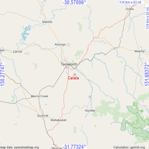
Calala GPS coordinates[2]
31° 10' 24.816" South, 150° 58' 50.124" East
| Map corner | latitude | longitude |
|---|---|---|
| Upper-left | -30.57006°, | 150.27747° |
| Center: | -31.17356°, | 150.98059° |
| Lower-right: | -31.77324°, | 151.68372° |
| Map W x H: | 133.8×133.8 km | = 83.1×83.1mi |
| max Lat: | -10.58257° ⇑29.8% North |
| Calala: | -31.17356° |
| min Lat: | ⇓70.2% South -43.31423° |
| min Long | Calala | max Long |
| 113.53327° | 150.98059° | 153.61246° |
| W 67.1%⇐ | ⇒32.9% E |
Elevation
Elevation of Calala is 428 m = 1404 ft, and this is 306 m = 1004 ft above average elevation for this country.
| Max E: |
1715 m = 5627 ft | 8.5% |
| Calala | 428 m 1404 ft | |
| Avg. | 122 m = 400 ft | |
Min E: |
-2 m = -7 ft | 91.5% |
See also: Australia elevation on elevation.city.
Geographical zone
Calala is located in South temperate zone (between Tropic of Capricorn and the Antarctic Circle). Distance of this Southern Tropic circle is 860.3 km =534.6 mi to North.| Distance of | km | miles | from Calala |
|---|---|---|---|
| Equator | 3466.2 | 2153.8 | to North |
| Tropic Capricorn | 860.3 | 534.6 | to North |
| Antarctic Circle | 3935 | 2445.1 | to South |
| South Pole | 6540.9 | 4064.3 | to South |


Nearby cities:
15 places around Calala: (largest is in red/bold)
• Daruka
15.2 km =9.4 mi,  356°
356°
• Duri
15.8 km =9.8 mi,  253°
253°
• East Tamworth
10.6 km =6.6 mi,  337°
337°
• Hillvue
8.7 km =5.4 mi,  306°
306°
• Kootingal
14.5 km =9 mi,  28°
28°
• Loomberah
12.7 km =7.9 mi,  163°
163°
• Moonbi
19.3 km =12 mi, 26°
• Nemingha
5.6 km =3.5 mi,  8°
8°
• North Tamworth
11.9 km =7.4 mi,  332°
332°
• Oxley Vale
14.4 km =8.9 mi, 328°
• Phillip
13.2 km =8.2 mi,  289°
289°
• South Tamworth
9 km =5.6 mi,  321°
321°
• Tamworth
10.5 km =6.5 mi, 332°
• West Tamworth
10.1 km =6.3 mi, 321°
• Westdale
15 km =9.3 mi, 308°
Sources, notices
• [Note1] Compared only with cities in Australia existing in our database
• [Src1] Map data: © OpenStreetMap contributors (CC-BY-SA)
• [Src2] Other city data from geonames.org with taken over terms of usage.
• [Src3] Geographical zone / Annual Mean Temperature by Robert A. Rohde @ Wikipedia
