Daruka geodata
Daruka (New South Wales) is a section of populated place; located in Australia in Australia/Sydney (GMT+11) time zone. With population of 764 people, there are 4216 cities with bigger population in this country. Compared to other cities in Australia, 70.7% of cities are located further ↓South; 67% of cities are located further ←West and 93.2% of cities have lower elevation than Daruka. Note1


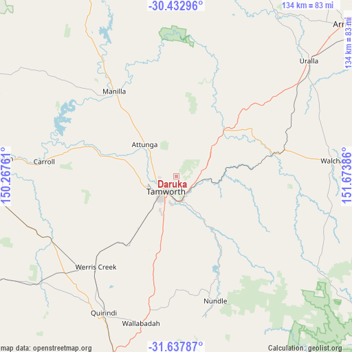
Daruka GPS coordinates[2]
31° 2' 14.352" South, 150° 58' 14.628" East
| Map corner | latitude | longitude |
|---|---|---|
| Upper-left | -30.43296°, | 150.26761° |
| Center: | -31.03732°, | 150.97073° |
| Lower-right: | -31.63787°, | 151.67386° |
| Map W x H: | 134×134 km | = 83.3×83.3mi |
| max Lat: | -10.58257° ⇑29.3% North |
| Daruka: | -31.03732° |
| min Lat: | ⇓70.7% South -43.31423° |
| min Long | Daruka | max Long |
| 113.53327° | 150.97073° | 153.61246° |
| W 67%⇐ | ⇒33% E |
Elevation
Elevation of Daruka is 485 m = 1591 ft, and this is 363 m = 1191 ft above average elevation for this country.
| Max E: |
1715 m = 5627 ft | 6.8% |
| Daruka | 485 m 1591 ft | |
| Avg. | 122 m = 400 ft | |
Min E: |
-2 m = -7 ft | 93.2% |
See also: Australia elevation on elevation.city.
Geographical zone
Daruka is located in South temperate zone (between Tropic of Capricorn and the Antarctic Circle). Distance of this Southern Tropic circle is 845.1 km =525.1 mi to North.| Distance of | km | miles | from Daruka |
|---|---|---|---|
| Equator | 3451 | 2144.4 | to North |
| Tropic Capricorn | 845.1 | 525.1 | to North |
| Antarctic Circle | 3950.1 | 2454.5 | to South |
| South Pole | 6556 | 4073.7 | to South |


Nearby cities:
15 places around Daruka: (largest is in red/bold)
• Calala
15.2 km =9.4 mi,  176°
176°
• East Tamworth
6.2 km =3.9 mi,  210°
210°
• Hallsville
9.7 km =6 mi,  287°
287°
• Hillvue
11.7 km =7.3 mi, 211°
• Kootingal
8.2 km =5.1 mi,  106°
106°
• Moonbi
9.8 km =6.1 mi,  77°
77°
• Moore
7.6 km =4.7 mi,  310°
310°
• Nemingha
9.8 km =6.1 mi,  169°
169°
• North Tamworth
6.5 km =4 mi,  225°
225°
• Oxley Vale
7.3 km =4.5 mi,  246°
246°
• Phillip
15.7 km =9.8 mi, 227°
• South Tamworth
9.3 km =5.8 mi, 209°
• Tamworth
7.1 km =4.4 mi, 213°
• West Tamworth
9 km =5.6 mi,  216°
216°
• Westdale
12.4 km =7.7 mi,  241°
241°
Sources, notices
• [Note1] Compared only with cities in Australia existing in our database
• [Src1] Map data: © OpenStreetMap contributors (CC-BY-SA)
• [Src2] Other city data from geonames.org with taken over terms of usage.
• [Src3] Geographical zone / Annual Mean Temperature by Robert A. Rohde @ Wikipedia
