Pooraka geodata
Pooraka (South Australia) is a section of populated place; located in Australia in Australia/Adelaide (GMT+10.5) time zone. With population of 7,158 people, there are 953 cities with bigger population in this country. Compared to other cities in Australia, 66.1% of cities are located further ↑North; 80.5% of cities are located further →East and 73.6% of cities have higher elevation than Pooraka. Note1


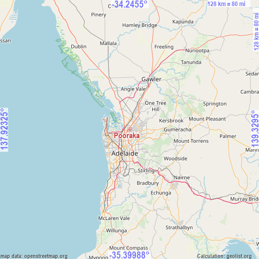
Pooraka GPS coordinates[2]
34° 49' 28.956" South, 138° 37' 34.932" East
| Map corner | latitude | longitude |
|---|---|---|
| Upper-left | -34.2455°, | 137.92325° |
| Center: | -34.82471°, | 138.62637° |
| Lower-right: | -35.39988°, | 139.3295° |
| Map W x H: | 128.4×128.4 km | = 79.8×79.8mi |
| max Lat: | -10.58257° ⇑66.1% North |
| Pooraka: | -34.82471° |
| min Lat: | ⇓33.9% South -43.31423° |
| min Long | Pooraka | max Long |
| 113.53327° | 138.62637° | 153.61246° |
| W 19.5%⇐ | ⇒80.5% E |
Elevation
Elevation of Pooraka is 20 m = 66 ft, and this is 102 m = 335 ft below average elevation for this country.
| Max E: |
1715 m = 5627 ft | 73.6% |
| Avg. | 122 m = 400 ft | |
| Pooraka | 20 m = 66 ft | |
Min E: |
-2 m = -7 ft | 26.4% |
See also: Australia elevation on elevation.city.
Geographical zone
Pooraka is located in South temperate zone (between Tropic of Capricorn and the Antarctic Circle). Distance of this Southern Tropic circle is 1266.2 km =786.8 mi to North.| Distance of | km | miles | from Pooraka |
|---|---|---|---|
| Equator | 3872.1 | 2406 | to North |
| Tropic Capricorn | 1266.2 | 786.8 | to North |
| Antarctic Circle | 3529 | 2192.8 | to South |
| South Pole | 6134.9 | 3812 | to South |


Nearby cities:
15 places around Pooraka: (largest is in red/bold)
• Clearview
3.8 km =2.4 mi,  198°
198°
• Enfield
3.8 km =2.4 mi,  215°
215°
• Gepps Cross
3.4 km =2.1 mi,  236°
236°
• Gilles Plains
3.5 km =2.2 mi,  142°
142°
• Ingle Farm
1.1 km =0.7 mi,  146°
146°
• Mawson Lakes
1.9 km =1.2 mi,  300°
300°
• Modbury North
4.4 km =2.7 mi,  95°
95°
• Northfield
2.8 km =1.7 mi,  181°
181°
• Northgate
3.7 km =2.3 mi, 176°
• Oakden
3.5 km =2.2 mi, 153°
• Para Hills
3.2 km =2 mi,  64°
64°
• Para Hills West
2.7 km =1.7 mi,  34°
34°
• Para Vista
3.2 km =2 mi,  82°
82°
• Valley View
3.6 km =2.2 mi,  118°
118°
• Walkley Heights
2.1 km =1.3 mi,  130°
130°
Sources, notices
• [Note1] Compared only with cities in Australia existing in our database
• [Src1] Map data: © OpenStreetMap contributors (CC-BY-SA)
• [Src2] Other city data from geonames.org with taken over terms of usage.
• [Src3] Geographical zone / Annual Mean Temperature by Robert A. Rohde @ Wikipedia
