Clearview geodata
Clearview (South Australia) is a section of populated place; located in Australia in Australia/Adelaide (GMT+10.5) time zone. With population of 3,743 people, there are 1903 cities with bigger population in this country. Compared to other cities in Australia, 66.8% of cities are located further ↑North; 80.9% of cities are located further →East and 57.4% of cities have lower elevation than Clearview. Note1


Clearview GPS coordinates[2]
34° 51' 26.46" South, 138° 36' 47.772" East
| Map corner | latitude | longitude |
|---|---|---|
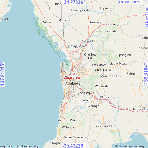
| Upper-left | -34.27836°, | 137.91015° |
| Center: | -34.85735°, | 138.61327° |
| Lower-right: | -35.43229°, | 139.3164° |
| Map W x H: | 128.3×128.3 km | = 79.7×79.7mi |
| max Lat: | -10.58257° ⇑66.8% North |
| Clearview: | -34.85735° |
| min Lat: | ⇓33.2% South -43.31423° |
| min Long | Clearview | max Long |
| 113.53327° | 138.61327° | 153.61246° |
| W 19.1%⇐ | ⇒80.9% E |
Elevation
Elevation of Clearview is 58 m = 190 ft, and this is 64 m = 210 ft below average elevation for this country.
| Max E: |
1715 m = 5627 ft | 42.6% |
| Avg. | 122 m = 400 ft | |
| Clearview | 58 m = 190 ft | |
Min E: |
-2 m = -7 ft | 57.4% |
See also: Australia elevation on elevation.city.
Geographical zone
Clearview is located in South temperate zone (between Tropic of Capricorn and the Antarctic Circle). Distance of this Southern Tropic circle is 1269.9 km =789.1 mi to North.| Distance of | km | miles | from Clearview |
|---|---|---|---|
| Equator | 3875.8 | 2408.3 | to North |
| Tropic Capricorn | 1269.9 | 789.1 | to North |
| Antarctic Circle | 3525.4 | 2190.6 | to South |
| South Pole | 6131.3 | 3809.8 | to South |


Nearby cities:
15 places around Clearview: (largest is in red/bold)
• Blair Athol
1.5 km =0.9 mi,  263°
263°
• Broadview
2.1 km =1.3 mi,  175°
175°
• Enfield
1.1 km =0.7 mi,  298°
298°
• Gepps Cross
2.4 km =1.5 mi,  317°
317°
• Greenacres
1.8 km =1.1 mi,  132°
132°
• Hampstead Gardens
2.4 km =1.5 mi,  143°
143°
• Hillcrest
2.8 km =1.7 mi,  101°
101°
• Ingle Farm
3.2 km =2 mi,  34°
34°
• Kilburn
2.5 km =1.6 mi, 264°
• Manningham
2.4 km =1.5 mi,  160°
160°
• Nailsworth
3.1 km =1.9 mi,  192°
192°
• Northfield
1.4 km =0.9 mi,  53°
53°
• Northgate
1.4 km =0.9 mi,  92°
92°
• Oakden
2.8 km =1.7 mi,  79°
79°
• Sefton Park
2.1 km =1.3 mi,  205°
205°
Sources, notices
• [Note1] Compared only with cities in Australia existing in our database
• [Src1] Map data: © OpenStreetMap contributors (CC-BY-SA)
• [Src2] Other city data from geonames.org with taken over terms of usage.
• [Src3] Geographical zone / Annual Mean Temperature by Robert A. Rohde @ Wikipedia
