Bellfield geodata
Bellfield (Victoria) is a section of populated place; located in Australia in Australia/Melbourne (GMT+11) time zone. With population of 1,770 people, there are 3073 cities with bigger population in this country. Compared to other cities in Australia, 86.2% of cities are located further ↑North; 65.5% of cities are located further →East and 60% of cities have lower elevation than Bellfield. Note1


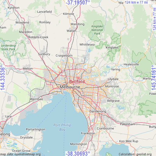
Bellfield GPS coordinates[2]
37° 45' 11.124" South, 145° 2' 18.528" East
| Map corner | latitude | longitude |
|---|---|---|
| Upper-left | -37.19507°, | 144.33536° |
| Center: | -37.75309°, | 145.03848° |
| Lower-right: | -38.30693°, | 145.74161° |
| Map W x H: | 123.6×123.6 km | = 76.8×76.8mi |
| max Lat: | -10.58257° ⇑86.2% North |
| Bellfield: | -37.75309° |
| min Lat: | ⇓13.8% South -43.31423° |
| min Long | Bellfield | max Long |
| 113.53327° | 145.03848° | 153.61246° |
| W 34.5%⇐ | ⇒65.5% E |
Elevation
Elevation of Bellfield is 64 m = 210 ft, and this is 58 m = 190 ft below average elevation for this country.
| Max E: |
1715 m = 5627 ft | 40% |
| Avg. | 122 m = 400 ft | |
| Bellfield | 64 m = 210 ft | |
Min E: |
-2 m = -7 ft | 60% |
See also: Australia elevation on elevation.city.
Geographical zone
Bellfield is located in South temperate zone (between Tropic of Capricorn and the Antarctic Circle). Distance of this Southern Tropic circle is 1591.8 km =989.1 mi to North.| Distance of | km | miles | from Bellfield |
|---|---|---|---|
| Equator | 4197.8 | 2608.4 | to North |
| Tropic Capricorn | 1591.8 | 989.1 | to North |
| Antarctic Circle | 3203.4 | 1990.5 | to South |
| South Pole | 5809.3 | 3609.7 | to South |


Nearby cities:
15 places around Bellfield: (largest is in red/bold)
• Alphington
3.4 km =2.1 mi,  187°
187°
• Bulleen
4.2 km =2.6 mi,  110°
110°
• Eaglemont
2.5 km =1.6 mi,  118°
118°
• Fairfield
3.5 km =2.2 mi,  211°
211°
• Heidelberg
2.5 km =1.6 mi,  82°
82°
• Heidelberg Heights
2 km =1.2 mi,  55°
55°
• Heidelberg West
1.6 km =1 mi,  6°
6°
• Ivanhoe
1.8 km =1.1 mi,  167°
167°
• Ivanhoe East
3.1 km =1.9 mi,  137°
137°
• Kingsbury
4.3 km =2.7 mi,  356°
356°
• Macleod
3.3 km =2.1 mi,  48°
48°
• Northcote
3.7 km =2.3 mi,  245°
245°
• Preston
1.9 km =1.2 mi,  280°
280°
• Rosanna
3 km =1.9 mi, 58°
• Thornbury
2.9 km =1.8 mi,  258°
258°
Sources, notices
• [Note1] Compared only with cities in Australia existing in our database
• [Src1] Map data: © OpenStreetMap contributors (CC-BY-SA)
• [Src2] Other city data from geonames.org with taken over terms of usage.
• [Src3] Geographical zone / Annual Mean Temperature by Robert A. Rohde @ Wikipedia
