Alphington geodata
Alphington (Victoria) is a section of populated place; located in Australia in Australia/Melbourne (GMT+11) time zone. With population of 4,603 people, there are 1597 cities with bigger population in this country. Compared to other cities in Australia, 87.1% of cities are located further ↑North; 65.8% of cities are located further →East and 56.9% of cities have higher elevation than Alphington. Note1


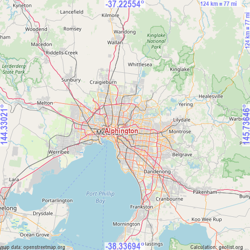
Alphington GPS coordinates[2]
37° 46' 59.988" South, 145° 1' 59.988" East
| Map corner | latitude | longitude |
|---|---|---|
| Upper-left | -37.22554°, | 144.33021° |
| Center: | -37.78333°, | 145.03333° |
| Lower-right: | -38.33694°, | 145.73646° |
| Map W x H: | 123.6×123.6 km | = 76.8×76.8mi |
| max Lat: | -10.58257° ⇑87.1% North |
| Alphington: | -37.78333° |
| min Lat: | ⇓12.9% South -43.31423° |
| min Long | Alphington | max Long |
| 113.53327° | 145.03333° | 153.61246° |
| W 34.2%⇐ | ⇒65.8% E |
Elevation
Elevation of Alphington is 36 m = 118 ft, and this is 86 m = 282 ft below average elevation for this country.
| Max E: |
1715 m = 5627 ft | 56.9% |
| Avg. | 122 m = 400 ft | |
| Alphington | 36 m = 118 ft | |
Min E: |
-2 m = -7 ft | 43.1% |
See also: Australia elevation on elevation.city.
Geographical zone
Alphington is located in South temperate zone (between Tropic of Capricorn and the Antarctic Circle). Distance of this Southern Tropic circle is 1595.2 km =991.2 mi to North.| Distance of | km | miles | from Alphington |
|---|---|---|---|
| Equator | 4201.1 | 2610.4 | to North |
| Tropic Capricorn | 1595.2 | 991.2 | to North |
| Antarctic Circle | 3200.1 | 1988.4 | to South |
| South Pole | 5805.9 | 3607.6 | to South |


Nearby cities:
15 places around Alphington: (largest is in red/bold)
• Abbotsford
3.5 km =2.2 mi,  237°
237°
• Bellfield
3.4 km =2.1 mi,  7°
7°
• Clifton Hill
3.7 km =2.3 mi, 243°
• Collingwood
4.5 km =2.8 mi, 241°
• Eaglemont
3.4 km =2.1 mi,  50°
50°
• Fairfield
1.4 km =0.9 mi,  286°
286°
• Hawthorn
4.1 km =2.5 mi,  176°
176°
• Heidelberg
4.7 km =2.9 mi,  38°
38°
• Ivanhoe
1.8 km =1.1 mi,  28°
28°
• Ivanhoe East
2.7 km =1.7 mi,  66°
66°
• Kew
2.6 km =1.6 mi, 184°
• Kew East
2.4 km =1.5 mi,  131°
131°
• Northcote
3.5 km =2.2 mi,  302°
302°
• Preston
4 km =2.5 mi,  338°
338°
• Thornbury
3.7 km =2.3 mi,  319°
319°
Sources, notices
• [Note1] Compared only with cities in Australia existing in our database
• [Src1] Map data: © OpenStreetMap contributors (CC-BY-SA)
• [Src2] Other city data from geonames.org with taken over terms of usage.
• [Src3] Geographical zone / Annual Mean Temperature by Robert A. Rohde @ Wikipedia
