Greenacres geodata
Greenacres (South Australia) is a section of populated place; located in Australia in Australia/Adelaide (GMT+10.5) time zone. With population of 2,837 people, there are 2357 cities with bigger population in this country. Compared to other cities in Australia, 67.2% of cities are located further ↑North; 80.4% of cities are located further →East and 62.4% of cities have lower elevation than Greenacres. Note1


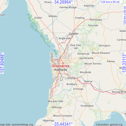
Greenacres GPS coordinates[2]
34° 52' 6.78" South, 138° 37' 40.8" East
| Map corner | latitude | longitude |
|---|---|---|
| Upper-left | -34.28964°, | 137.92488° |
| Center: | -34.86855°, | 138.628° |
| Lower-right: | -35.44341°, | 139.33113° |
| Map W x H: | 128.3×128.3 km | = 79.7×79.7mi |
| max Lat: | -10.58257° ⇑67.2% North |
| Greenacres: | -34.86855° |
| min Lat: | ⇓32.8% South -43.31423° |
| min Long | Greenacres | max Long |
| 113.53327° | 138.628° | 153.61246° |
| W 19.6%⇐ | ⇒80.4% E |
Elevation
Elevation of Greenacres is 71 m = 233 ft, and this is 51 m = 167 ft below average elevation for this country.
| Max E: |
1715 m = 5627 ft | 37.6% |
| Avg. | 122 m = 400 ft | |
| Greenacres | 71 m = 233 ft | |
Min E: |
-2 m = -7 ft | 62.4% |
See also: Australia elevation on elevation.city.
Geographical zone
Greenacres is located in South temperate zone (between Tropic of Capricorn and the Antarctic Circle). Distance of this Southern Tropic circle is 1271.1 km =789.8 mi to North.| Distance of | km | miles | from Greenacres |
|---|---|---|---|
| Equator | 3877 | 2409.1 | to North |
| Tropic Capricorn | 1271.1 | 789.8 | to North |
| Antarctic Circle | 3524.2 | 2189.8 | to South |
| South Pole | 6130 | 3809 | to South |


Nearby cities:
15 places around Greenacres: (largest is in red/bold)
• Broadview
1.4 km =0.9 mi,  235°
235°
• Clearview
1.8 km =1.1 mi,  312°
312°
• Collinswood
2.5 km =1.6 mi,  214°
214°
• Gilles Plains
2.9 km =1.8 mi,  44°
44°
• Hampstead Gardens
0.7 km =0.4 mi,  173°
173°
• Hillcrest
1.5 km =0.9 mi,  63°
63°
• Klemzig
1.4 km =0.9 mi,  149°
149°
• Manningham
1.2 km =0.7 mi, 207°
• Nailsworth
2.7 km =1.7 mi,  228°
228°
• Northfield
2.1 km =1.3 mi,  353°
353°
• Northgate
1.2 km =0.7 mi,  4°
4°
• Oakden
2.2 km =1.4 mi, 38°
• Sefton Park
2.3 km =1.4 mi,  254°
254°
• Vale Park
1.9 km =1.2 mi,  182°
182°
• Windsor Gardens
1.8 km =1.1 mi,  78°
78°
Sources, notices
• [Note1] Compared only with cities in Australia existing in our database
• [Src1] Map data: © OpenStreetMap contributors (CC-BY-SA)
• [Src2] Other city data from geonames.org with taken over terms of usage.
• [Src3] Geographical zone / Annual Mean Temperature by Robert A. Rohde @ Wikipedia
