Hamilton geodata
Hamilton (New South Wales) is a section of populated place; located in Australia in Australia/Sydney (GMT+11) time zone. With population of 4,187 people, there are 1722 cities with bigger population in this country. Compared to other cities in Australia, 58.6% of cities are located further ↓South; 81% of cities are located further ←West and 85% of cities have higher elevation than Hamilton. Note1


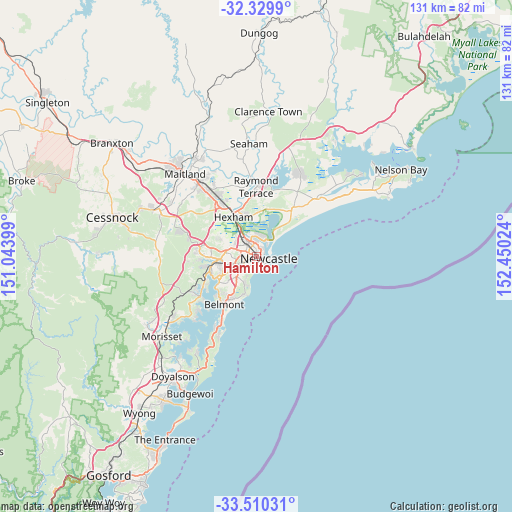
Hamilton GPS coordinates[2]
32° 55' 19.452" South, 151° 44' 49.596" East
| Map corner | latitude | longitude |
|---|---|---|
| Upper-left | -32.3299°, | 151.04399° |
| Center: | -32.92207°, | 151.74711° |
| Lower-right: | -33.51031°, | 152.45024° |
| Map W x H: | 131.2×131.2 km | = 81.5×81.5mi |
| max Lat: | -10.58257° ⇑41.4% North |
| Hamilton: | -32.92207° |
| min Lat: | ⇓58.6% South -43.31423° |
| min Long | Hamilton | max Long |
| 113.53327° | 151.74711° | 153.61246° |
| W 81%⇐ | ⇒19% E |
Elevation
Elevation of Hamilton is 12 m = 39 ft, and this is 110 m = 361 ft below average elevation for this country.
| Max E: |
1715 m = 5627 ft | 85% |
| Avg. | 122 m = 400 ft | |
| Hamilton | 12 m = 39 ft | |
Min E: |
-2 m = -7 ft | 15% |
See also: Australia elevation on elevation.city.
Geographical zone
Hamilton is located in South temperate zone (between Tropic of Capricorn and the Antarctic Circle). Distance of this Southern Tropic circle is 1054.7 km =655.4 mi to North.| Distance of | km | miles | from Hamilton |
|---|---|---|---|
| Equator | 3660.6 | 2274.6 | to North |
| Tropic Capricorn | 1054.7 | 655.4 | to North |
| Antarctic Circle | 3740.6 | 2324.3 | to South |
| South Pole | 6346.5 | 3943.5 | to South |


Nearby cities:
15 places around Hamilton: (largest is in red/bold)
• Bar Beach
2.7 km =1.7 mi,  141°
141°
• Broadmeadow
1.7 km =1.1 mi,  264°
264°
• Carrington
1.8 km =1.1 mi,  64°
64°
• Cooks Hill
2.5 km =1.6 mi,  117°
117°
• Georgetown
2.1 km =1.3 mi,  316°
316°
• Hamilton East
0.7 km =0.4 mi, 124°
• Hamilton North
1.5 km =0.9 mi, 319°
• Islington
0.9 km =0.6 mi,  1°
1°
• Maryville
1.4 km =0.9 mi,  32°
32°
• Mayfield East
2.4 km =1.5 mi,  5°
5°
• Newcastle West
1 km =0.6 mi,  105°
105°
• The Junction
2.1 km =1.3 mi,  148°
148°
• Tighes Hill
1.7 km =1.1 mi, 12°
• Waratah
2.6 km =1.6 mi,  311°
311°
• Wickham
1 km =0.6 mi,  70°
70°
Sources, notices
• [Note1] Compared only with cities in Australia existing in our database
• [Src1] Map data: © OpenStreetMap contributors (CC-BY-SA)
• [Src2] Other city data from geonames.org with taken over terms of usage.
• [Src3] Geographical zone / Annual Mean Temperature by Robert A. Rohde @ Wikipedia
