Aveley geodata
Aveley (Western Australia) is a section of populated place; located in Australia in Australia/Perth (GMT+8) time zone. With population of 9,952 people, there are 604 cities with bigger population in this country. Compared to other cities in Australia, 68.3% of cities are located further ↓South; 92.5% of cities are located further →East and 65.9% of cities have higher elevation than Aveley. Note1


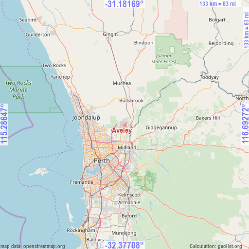
Aveley GPS coordinates[2]
31° 46' 52.752" South, 115° 59' 22.524" East
| Map corner | latitude | longitude |
|---|---|---|
| Upper-left | -31.18169°, | 115.28647° |
| Center: | -31.78132°, | 115.98959° |
| Lower-right: | -32.37708°, | 116.69272° |
| Map W x H: | 132.9×132.9 km | = 82.6×82.6mi |
| max Lat: | -10.58257° ⇑31.7% North |
| Aveley: | -31.78132° |
| min Lat: | ⇓68.3% South -43.31423° |
| min Long | Aveley | max Long |
| 113.53327° | 115.98959° | 153.61246° |
| W 7.5%⇐ | ⇒92.5% E |
Elevation
Elevation of Aveley is 26 m = 85 ft, and this is 96 m = 315 ft below average elevation for this country.
| Max E: |
1715 m = 5627 ft | 65.9% |
| Avg. | 122 m = 400 ft | |
| Aveley | 26 m = 85 ft | |
Min E: |
-2 m = -7 ft | 34.1% |
See also: Australia elevation on elevation.city.
Geographical zone
Aveley is located in South temperate zone (between Tropic of Capricorn and the Antarctic Circle). Distance of this Southern Tropic circle is 927.8 km =576.5 mi to North.| Distance of | km | miles | from Aveley |
|---|---|---|---|
| Equator | 3533.8 | 2195.8 | to North |
| Tropic Capricorn | 927.8 | 576.5 | to North |
| Antarctic Circle | 3867.4 | 2403.1 | to South |
| South Pole | 6473.3 | 4022.3 | to South |


Nearby cities:
15 places around Aveley: (largest is in red/bold)
• Beechboro
10.6 km =6.6 mi,  208°
208°
• Bennett Springs
9.6 km =6 mi, 205°
• Brabham
5.3 km =3.3 mi,  195°
195°
• Brigadoon
7.9 km =4.9 mi,  82°
82°
• Dayton
8 km =5 mi,  189°
189°
• Ellenbrook
2.5 km =1.6 mi,  309°
309°
• Henley Brook
3.6 km =2.2 mi,  182°
182°
• Herne Hill
5.8 km =3.6 mi,  147°
147°
• Jane Brook
10.8 km =6.7 mi, 147°
• Middle Swan
8.1 km =5 mi,  161°
161°
• Millendon
5.3 km =3.3 mi,  123°
123°
• Stratton
10.8 km =6.7 mi, 153°
• The Vines
3.2 km =2 mi,  22°
22°
• Upper Swan
3.8 km =2.4 mi,  69°
69°
• West Swan
7.4 km =4.6 mi, 187°
Sources, notices
• [Note1] Compared only with cities in Australia existing in our database
• [Src1] Map data: © OpenStreetMap contributors (CC-BY-SA)
• [Src2] Other city data from geonames.org with taken over terms of usage.
• [Src3] Geographical zone / Annual Mean Temperature by Robert A. Rohde @ Wikipedia
