Millendon geodata
Millendon (Western Australia) is a populated place; located in Australia in Australia/Perth (GMT+8) time zone. With population of 515 people, there are 4834 cities with bigger population in this country. Compared to other cities in Australia, 68.1% of cities are located further ↓South; 92% of cities are located further →East and 70.9% of cities have higher elevation than Millendon. Note1


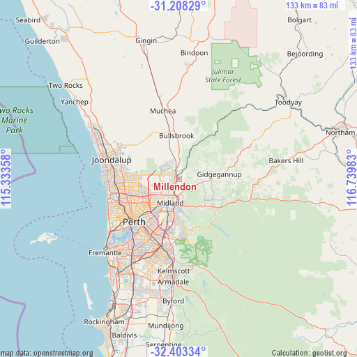
Millendon GPS coordinates[2]
31° 48' 27.9" South, 116° 2' 12.12" East
| Map corner | latitude | longitude |
|---|---|---|
| Upper-left | -31.20829°, | 115.33358° |
| Center: | -31.80775°, | 116.0367° |
| Lower-right: | -32.40334°, | 116.73983° |
| Map W x H: | 132.9×132.9 km | = 82.6×82.6mi |
| max Lat: | -10.58257° ⇑31.9% North |
| Millendon: | -31.80775° |
| min Lat: | ⇓68.1% South -43.31423° |
| min Long | Millendon | max Long |
| 113.53327° | 116.0367° | 153.61246° |
| W 8%⇐ | ⇒92% E |
Elevation
Elevation of Millendon is 22 m = 72 ft, and this is 100 m = 328 ft below average elevation for this country.
| Max E: |
1715 m = 5627 ft | 70.9% |
| Avg. | 122 m = 400 ft | |
| Millendon | 22 m = 72 ft | |
Min E: |
-2 m = -7 ft | 29.1% |
See also: Australia elevation on elevation.city.
Geographical zone
Millendon is located in South temperate zone (between Tropic of Capricorn and the Antarctic Circle). Distance of this Southern Tropic circle is 930.8 km =578.4 mi to North.| Distance of | km | miles | from Millendon |
|---|---|---|---|
| Equator | 3536.7 | 2197.6 | to North |
| Tropic Capricorn | 930.8 | 578.4 | to North |
| Antarctic Circle | 3864.5 | 2401.3 | to South |
| South Pole | 6470.4 | 4020.5 | to South |


Nearby cities:
15 places around Millendon: (largest is in red/bold)
• Aveley
5.3 km =3.3 mi,  303°
303°
• Brabham
6.3 km =3.9 mi,  249°
249°
• Brigadoon
5.2 km =3.2 mi,  41°
41°
• Dayton
7.7 km =4.8 mi,  229°
229°
• Ellenbrook
7.8 km =4.8 mi,  305°
305°
• Henley Brook
4.6 km =2.9 mi,  261°
261°
• Herne Hill
2.4 km =1.5 mi,  213°
213°
• Jane Brook
6.4 km =4 mi,  168°
168°
• Middle Swan
5.1 km =3.2 mi,  201°
201°
• Stratton
6.7 km =4.2 mi,  176°
176°
• Swan View
8.5 km =5.3 mi, 171°
• The Vines
6.7 km =4.2 mi,  331°
331°
• Upper Swan
4.3 km =2.7 mi,  348°
348°
• Viveash
8.7 km =5.4 mi, 205°
• West Swan
7 km =4.3 mi, 230°
Sources, notices
• [Note1] Compared only with cities in Australia existing in our database
• [Src1] Map data: © OpenStreetMap contributors (CC-BY-SA)
• [Src2] Other city data from geonames.org with taken over terms of usage.
• [Src3] Geographical zone / Annual Mean Temperature by Robert A. Rohde @ Wikipedia
