Lakelands geodata
Lakelands (New South Wales) is a section of populated place; located in Australia in Australia/Sydney (GMT+11) time zone. With population of 1,382 people, there are 3387 cities with bigger population in this country. Compared to other cities in Australia, 57.9% of cities are located further ↓South; 79.8% of cities are located further ←West and 54.5% of cities have higher elevation than Lakelands. Note1


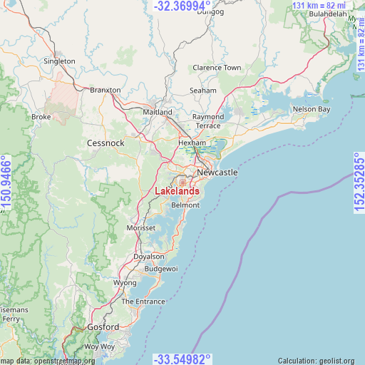
Lakelands GPS coordinates[2]
32° 57' 42.66" South, 151° 38' 58.992" East
| Map corner | latitude | longitude |
|---|---|---|
| Upper-left | -32.36994°, | 150.9466° |
| Center: | -32.96185°, | 151.64972° |
| Lower-right: | -33.54982°, | 152.35285° |
| Map W x H: | 131.2×131.2 km | = 81.5×81.5mi |
| max Lat: | -10.58257° ⇑42.1% North |
| Lakelands: | -32.96185° |
| min Lat: | ⇓57.9% South -43.31423° |
| min Long | Lakelands | max Long |
| 113.53327° | 151.64972° | 153.61246° |
| W 79.8%⇐ | ⇒20.2% E |
Elevation
Elevation of Lakelands is 39 m = 128 ft, and this is 83 m = 272 ft below average elevation for this country.
| Max E: |
1715 m = 5627 ft | 54.5% |
| Avg. | 122 m = 400 ft | |
| Lakelands | 39 m = 128 ft | |
Min E: |
-2 m = -7 ft | 45.5% |
See also: Australia elevation on elevation.city.
Geographical zone
Lakelands is located in South temperate zone (between Tropic of Capricorn and the Antarctic Circle). Distance of this Southern Tropic circle is 1059.1 km =658.1 mi to North.| Distance of | km | miles | from Lakelands |
|---|---|---|---|
| Equator | 3665 | 2277.3 | to North |
| Tropic Capricorn | 1059.1 | 658.1 | to North |
| Antarctic Circle | 3736.2 | 2321.6 | to South |
| South Pole | 6342 | 3940.7 | to South |


Nearby cities:
15 places around Lakelands: (largest is in red/bold)
• Argenton
3.5 km =2.2 mi,  329°
329°
• Boolaroo
2.6 km =1.6 mi,  308°
308°
• Cardiff
2.2 km =1.4 mi,  11°
11°
• Cardiff Heights
3.5 km =2.2 mi,  36°
36°
• Cardiff South
1.6 km =1 mi,  59°
59°
• Eleebana
3.3 km =2.1 mi,  201°
201°
• Garden Suburb
3.5 km =2.2 mi, 55°
• Glendale
3.4 km =2.1 mi,  346°
346°
• Hillsborough
2.2 km =1.4 mi,  100°
100°
• Kotara South
4 km =2.5 mi,  74°
74°
• Macquarie Hills
1.3 km =0.8 mi,  338°
338°
• Marmong Point
3.6 km =2.2 mi,  234°
234°
• Mount Hutton
3.1 km =1.9 mi,  141°
141°
• Speers Point
2.2 km =1.4 mi,  264°
264°
• Warners Bay
1.2 km =0.7 mi,  166°
166°
Sources, notices
• [Note1] Compared only with cities in Australia existing in our database
• [Src1] Map data: © OpenStreetMap contributors (CC-BY-SA)
• [Src2] Other city data from geonames.org with taken over terms of usage.
• [Src3] Geographical zone / Annual Mean Temperature by Robert A. Rohde @ Wikipedia
