Glendale geodata
Glendale (New South Wales) is a section of populated place; located in Australia in Australia/Sydney (GMT+11) time zone. With population of 3,067 people, there are 2217 cities with bigger population in this country. Compared to other cities in Australia, 58.4% of cities are located further ↓South; 79.6% of cities are located further ←West and 91.8% of cities have higher elevation than Glendale. Note1


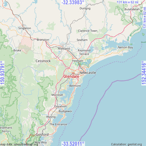
Glendale GPS coordinates[2]
32° 55' 54.984" South, 151° 38' 27.708" East
| Map corner | latitude | longitude |
|---|---|---|
| Upper-left | -32.33983°, | 150.93791° |
| Center: | -32.93194°, | 151.64103° |
| Lower-right: | -33.52011°, | 152.34416° |
| Map W x H: | 131.2×131.2 km | = 81.5×81.5mi |
| max Lat: | -10.58257° ⇑41.6% North |
| Glendale: | -32.93194° |
| min Lat: | ⇓58.4% South -43.31423° |
| min Long | Glendale | max Long |
| 113.53327° | 151.64103° | 153.61246° |
| W 79.6%⇐ | ⇒20.4% E |
Elevation
Elevation of Glendale is 8 m = 26 ft, and this is 114 m = 374 ft below average elevation for this country.
| Max E: |
1715 m = 5627 ft | 91.8% |
| Avg. | 122 m = 400 ft | |
| Glendale | 8 m = 26 ft | |
Min E: |
-2 m = -7 ft | 8.2% |
See also: Australia elevation on elevation.city.
Geographical zone
Glendale is located in South temperate zone (between Tropic of Capricorn and the Antarctic Circle). Distance of this Southern Tropic circle is 1055.8 km =656 mi to North.| Distance of | km | miles | from Glendale |
|---|---|---|---|
| Equator | 3661.7 | 2275.3 | to North |
| Tropic Capricorn | 1055.8 | 656 | to North |
| Antarctic Circle | 3739.5 | 2323.6 | to South |
| South Pole | 6345.4 | 3942.8 | to South |


Nearby cities:
15 places around Glendale: (largest is in red/bold)
• Argenton
1 km =0.6 mi,  250°
250°
• Boolaroo
2.1 km =1.3 mi,  216°
216°
• Cameron Park
4.3 km =2.7 mi,  309°
309°
• Cardiff
1.7 km =1.1 mi,  131°
131°
• Cardiff Heights
3 km =1.9 mi,  99°
99°
• Cardiff South
3.3 km =2.1 mi,  139°
139°
• Edgeworth
2.4 km =1.5 mi,  288°
288°
• Elermore Vale
3.8 km =2.4 mi,  62°
62°
• Garden Suburb
3.9 km =2.4 mi,  109°
109°
• Lakelands
3.4 km =2.1 mi,  166°
166°
• Macquarie Hills
2.2 km =1.4 mi, 171°
• Rankin Park
3.7 km =2.3 mi,  78°
78°
• Speers Point
3.8 km =2.4 mi,  201°
201°
• Wallsend
4 km =2.5 mi,  32°
32°
• Warners Bay
4.6 km =2.9 mi, 166°
Sources, notices
• [Note1] Compared only with cities in Australia existing in our database
• [Src1] Map data: © OpenStreetMap contributors (CC-BY-SA)
• [Src2] Other city data from geonames.org with taken over terms of usage.
• [Src3] Geographical zone / Annual Mean Temperature by Robert A. Rohde @ Wikipedia
