Delahey geodata
Delahey (Victoria) is a section of populated place; located in Australia in Australia/Melbourne (GMT+11) time zone. With population of 8,287 people, there are 787 cities with bigger population in this country. Compared to other cities in Australia, 85.3% of cities are located further ↑North; 69% of cities are located further →East and 68.7% of cities have lower elevation than Delahey. Note1


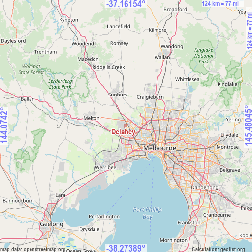
Delahey GPS coordinates[2]
37° 43' 11.28" South, 144° 46' 38.352" East
| Map corner | latitude | longitude |
|---|---|---|
| Upper-left | -37.16154°, | 144.0742° |
| Center: | -37.7198°, | 144.77732° |
| Lower-right: | -38.27389°, | 145.48045° |
| Map W x H: | 123.7×123.7 km | = 76.9×76.9mi |
| max Lat: | -10.58257° ⇑85.3% North |
| Delahey: | -37.7198° |
| min Lat: | ⇓14.7% South -43.31423° |
| min Long | Delahey | max Long |
| 113.53327° | 144.77732° | 153.61246° |
| W 31%⇐ | ⇒69% E |
Elevation
Elevation of Delahey is 95 m = 312 ft, and this is 27 m = 89 ft below average elevation for this country.
| Max E: |
1715 m = 5627 ft | 31.3% |
| Avg. | 122 m = 400 ft | |
| Delahey | 95 m = 312 ft | |
Min E: |
-2 m = -7 ft | 68.7% |
See also: Australia elevation on elevation.city.
Geographical zone
Delahey is located in South temperate zone (between Tropic of Capricorn and the Antarctic Circle). Distance of this Southern Tropic circle is 1588.1 km =986.8 mi to North.| Distance of | km | miles | from Delahey |
|---|---|---|---|
| Equator | 4194 | 2606 | to North |
| Tropic Capricorn | 1588.1 | 986.8 | to North |
| Antarctic Circle | 3207.1 | 1992.8 | to South |
| South Pole | 5813 | 3612 | to South |


Nearby cities:
15 places around Delahey: (largest is in red/bold)
• Albanvale
3 km =1.9 mi,  194°
194°
• Burnside
3.9 km =2.4 mi,  213°
213°
• Burnside Heights
2.3 km =1.4 mi,  250°
250°
• Cairnlea
4.5 km =2.8 mi,  168°
168°
• Caroline Springs
4.3 km =2.7 mi,  236°
236°
• Hillside
4.5 km =2.8 mi,  316°
316°
• Keilor
4.9 km =3 mi,  85°
85°
• Keilor Downs
2.8 km =1.7 mi,  98°
98°
• Keilor Lodge
3.2 km =2 mi,  46°
46°
• Kings Park
1.6 km =1 mi,  178°
178°
• Saint Albans
2.5 km =1.6 mi,  127°
127°
• St Albans
3.5 km =2.2 mi,  143°
143°
• Sydenham
2.4 km =1.5 mi,  336°
336°
• Taylors Hill
2.3 km =1.4 mi,  299°
299°
• Taylors Lakes
2.5 km =1.6 mi,  18°
18°
Sources, notices
• [Note1] Compared only with cities in Australia existing in our database
• [Src1] Map data: © OpenStreetMap contributors (CC-BY-SA)
• [Src2] Other city data from geonames.org with taken over terms of usage.
• [Src3] Geographical zone / Annual Mean Temperature by Robert A. Rohde @ Wikipedia
