Keilor geodata
Keilor (Victoria) is a section of populated place; located in Australia in Australia/Melbourne (GMT+11) time zone. With population of 5,730 people, there are 1280 cities with bigger population in this country. Compared to other cities in Australia, 85.2% of cities are located further ↑North; 68.6% of cities are located further →East and 55.2% of cities have higher elevation than Keilor. Note1


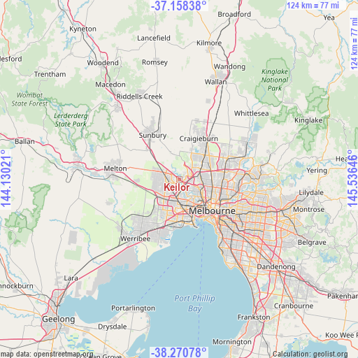
Keilor GPS coordinates[2]
37° 43' 0.012" South, 144° 49' 59.988" East
| Map corner | latitude | longitude |
|---|---|---|
| Upper-left | -37.15838°, | 144.13021° |
| Center: | -37.71667°, | 144.83333° |
| Lower-right: | -38.27078°, | 145.53646° |
| Map W x H: | 123.7×123.7 km | = 76.9×76.9mi |
| max Lat: | -10.58257° ⇑85.2% North |
| Keilor: | -37.71667° |
| min Lat: | ⇓14.8% South -43.31423° |
| min Long | Keilor | max Long |
| 113.53327° | 144.83333° | 153.61246° |
| W 31.4%⇐ | ⇒68.6% E |
Elevation
Elevation of Keilor is 38 m = 125 ft, and this is 84 m = 276 ft below average elevation for this country.
| Max E: |
1715 m = 5627 ft | 55.2% |
| Avg. | 122 m = 400 ft | |
| Keilor | 38 m = 125 ft | |
Min E: |
-2 m = -7 ft | 44.8% |
See also: Australia elevation on elevation.city.
Geographical zone
Keilor is located in South temperate zone (between Tropic of Capricorn and the Antarctic Circle). Distance of this Southern Tropic circle is 1587.8 km =986.6 mi to North.| Distance of | km | miles | from Keilor |
|---|---|---|---|
| Equator | 4193.7 | 2605.8 | to North |
| Tropic Capricorn | 1587.8 | 986.6 | to North |
| Antarctic Circle | 3207.5 | 1993 | to South |
| South Pole | 5813.4 | 3612.3 | to South |


Nearby cities:
15 places around Keilor: (largest is in red/bold)
• Airport West
4.3 km =2.7 mi,  101°
101°
• Delahey
4.9 km =3 mi,  265°
265°
• Gowanbrae
5.1 km =3.2 mi,  79°
79°
• Kealba
2.3 km =1.4 mi,  191°
191°
• Keilor Downs
2.3 km =1.4 mi,  251°
251°
• Keilor East
3.3 km =2.1 mi,  122°
122°
• Keilor Lodge
3.2 km =2 mi,  305°
305°
• Keilor Park
1.9 km =1.2 mi, 102°
• Kings Park
5.3 km =3.3 mi, 248°
• Melbourne Airport
5 km =3.1 mi,  19°
19°
• Saint Albans
3.5 km =2.2 mi,  237°
237°
• St Albans
4.3 km =2.7 mi,  222°
222°
• Strathmore Heights
5.6 km =3.5 mi,  86°
86°
• Taylors Lakes
4.6 km =2.9 mi,  295°
295°
• Tullamarine
4.5 km =2.8 mi,  67°
67°
Sources, notices
• [Note1] Compared only with cities in Australia existing in our database
• [Src1] Map data: © OpenStreetMap contributors (CC-BY-SA)
• [Src2] Other city data from geonames.org with taken over terms of usage.
• [Src3] Geographical zone / Annual Mean Temperature by Robert A. Rohde @ Wikipedia
