Castlereagh geodata
Castlereagh (New South Wales) is a section of populated place; located in Australia in Australia/Sydney (GMT+11) time zone. With population of 1,148 people, there are 3645 cities with bigger population in this country. Compared to other cities in Australia, 51.5% of cities are located further ↓South; 60.5% of cities are located further ←West and 73.6% of cities have higher elevation than Castlereagh. Note1


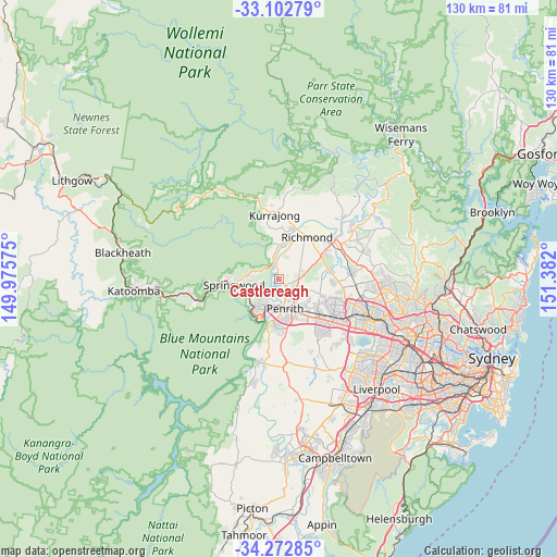
Castlereagh GPS coordinates[2]
33° 41' 23.316" South, 150° 40' 43.932" East
| Map corner | latitude | longitude |
|---|---|---|
| Upper-left | -33.10279°, | 149.97575° |
| Center: | -33.68981°, | 150.67887° |
| Lower-right: | -34.27285°, | 151.382° |
| Map W x H: | 130.1×130.1 km | = 80.8×80.8mi |
| max Lat: | -10.58257° ⇑48.5% North |
| Castlereagh: | -33.68981° |
| min Lat: | ⇓51.5% South -43.31423° |
| min Long | Castlereagh | max Long |
| 113.53327° | 150.67887° | 153.61246° |
| W 60.5%⇐ | ⇒39.5% E |
Elevation
Elevation of Castlereagh is 20 m = 66 ft, and this is 102 m = 335 ft below average elevation for this country.
| Max E: |
1715 m = 5627 ft | 73.6% |
| Avg. | 122 m = 400 ft | |
| Castlereagh | 20 m = 66 ft | |
Min E: |
-2 m = -7 ft | 26.4% |
See also: Australia elevation on elevation.city.
Geographical zone
Castlereagh is located in South temperate zone (between Tropic of Capricorn and the Antarctic Circle). Distance of this Southern Tropic circle is 1140 km =708.4 mi to North.| Distance of | km | miles | from Castlereagh |
|---|---|---|---|
| Equator | 3746 | 2327.7 | to North |
| Tropic Capricorn | 1140 | 708.4 | to North |
| Antarctic Circle | 3655.2 | 2271.2 | to South |
| South Pole | 6261.1 | 3890.5 | to South |


Nearby cities:
15 places around Castlereagh: (largest is in red/bold)
• Cambridge Gardens
6.6 km =4.1 mi,  144°
144°
• Cambridge Park
7.6 km =4.7 mi,  148°
148°
• Cranebrook
3.4 km =2.1 mi,  122°
122°
• Emu Heights
5.7 km =3.5 mi,  209°
209°
• Emu Plains
6.8 km =4.2 mi,  189°
189°
• Jordan Springs
5.8 km =3.6 mi,  127°
127°
• Llandilo
6.8 km =4.2 mi,  112°
112°
• Londonderry
7.1 km =4.4 mi,  47°
47°
• Mount Riverview
6.1 km =3.8 mi,  221°
221°
• Penrith
7 km =4.3 mi,  163°
163°
• Warrimoo
7.9 km =4.9 mi,  247°
247°
• Werrington Downs
7.4 km =4.6 mi, 142°
• Winmalee
6.3 km =3.9 mi,  281°
281°
• Yarramundi
7.8 km =4.8 mi,  357°
357°
• Yellow Rock
4.2 km =2.6 mi,  256°
256°
Sources, notices
• [Note1] Compared only with cities in Australia existing in our database
• [Src1] Map data: © OpenStreetMap contributors (CC-BY-SA)
• [Src2] Other city data from geonames.org with taken over terms of usage.
• [Src3] Geographical zone / Annual Mean Temperature by Robert A. Rohde @ Wikipedia
