Yarramundi geodata
Yarramundi (New South Wales) is a populated place; located in Australia in Australia/Sydney (GMT+11) time zone. With population of 841 people, there are 4074 cities with bigger population in this country. Compared to other cities in Australia, 52.4% of cities are located further ↓South; 60.4% of cities are located further ←West and 55.4% of cities have lower elevation than Yarramundi. Note1


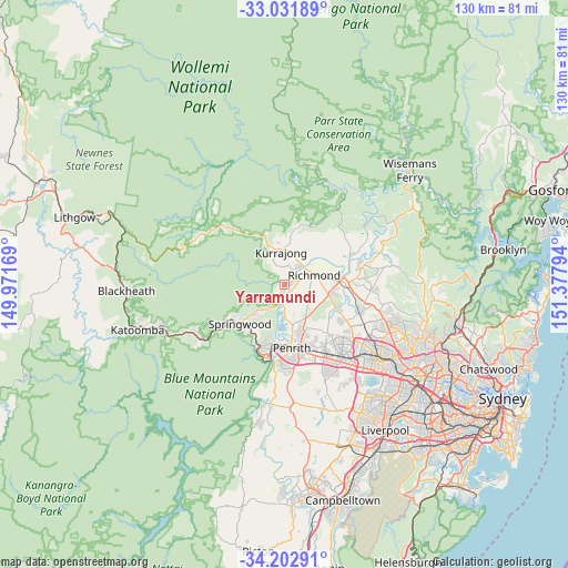
Yarramundi GPS coordinates[2]
33° 37' 9.804" South, 150° 40' 29.316" East
| Map corner | latitude | longitude |
|---|---|---|
| Upper-left | -33.03189°, | 149.97169° |
| Center: | -33.61939°, | 150.67481° |
| Lower-right: | -34.20291°, | 151.37794° |
| Map W x H: | 130.2×130.2 km | = 80.9×80.9mi |
| max Lat: | -10.58257° ⇑47.6% North |
| Yarramundi: | -33.61939° |
| min Lat: | ⇓52.4% South -43.31423° |
| min Long | Yarramundi | max Long |
| 113.53327° | 150.67481° | 153.61246° |
| W 60.4%⇐ | ⇒39.6% E |
Elevation
Elevation of Yarramundi is 54 m = 177 ft, and this is 68 m = 223 ft below average elevation for this country.
| Max E: |
1715 m = 5627 ft | 44.6% |
| Avg. | 122 m = 400 ft | |
| Yarramundi | 54 m = 177 ft | |
Min E: |
-2 m = -7 ft | 55.4% |
See also: Australia elevation on elevation.city.
Geographical zone
Yarramundi is located in South temperate zone (between Tropic of Capricorn and the Antarctic Circle). Distance of this Southern Tropic circle is 1132.2 km =703.5 mi to North.| Distance of | km | miles | from Yarramundi |
|---|---|---|---|
| Equator | 3738.1 | 2322.7 | to North |
| Tropic Capricorn | 1132.2 | 703.5 | to North |
| Antarctic Circle | 3663 | 2276.1 | to South |
| South Pole | 6268.9 | 3895.3 | to South |


Nearby cities:
15 places around Yarramundi: (largest is in red/bold)
• Agnes Banks
4 km =2.5 mi,  74°
74°
• Berkshire Park
11 km =6.8 mi,  122°
122°
• Bowen Mountain
7 km =4.3 mi,  319°
319°
• Castlereagh
7.8 km =4.8 mi,  177°
177°
• Cranebrook
10.2 km =6.3 mi,  161°
161°
• Grose Vale
4 km =2.5 mi,  359°
359°
• Grose Wold
2.5 km =1.6 mi,  21°
21°
• Hobartville
6.5 km =4 mi,  75°
75°
• Kurmond
7.6 km =4.7 mi,  14°
14°
• Kurrajong Hills
9.8 km =6.1 mi,  347°
347°
• Londonderry
6.4 km =4 mi, 118°
• North Richmond
5.9 km =3.7 mi,  44°
44°
• Richmond
7.4 km =4.6 mi, 72°
• Winmalee
8.8 km =5.5 mi,  221°
221°
• Yellow Rock
9.6 km =6 mi,  202°
202°
Sources, notices
• [Note1] Compared only with cities in Australia existing in our database
• [Src1] Map data: © OpenStreetMap contributors (CC-BY-SA)
• [Src2] Other city data from geonames.org with taken over terms of usage.
• [Src3] Geographical zone / Annual Mean Temperature by Robert A. Rohde @ Wikipedia
