Chiswick geodata
Chiswick (New South Wales) is a section of populated place; located in Australia in Australia/Sydney (GMT+11) time zone. With population of 2,878 people, there are 2330 cities with bigger population in this country. Compared to other cities in Australia, 53.7% of cities are located further ↑North; 71.4% of cities are located further ←West and 76.1% of cities have higher elevation than Chiswick. Note1


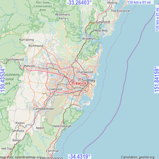
Chiswick GPS coordinates[2]
33° 50' 59.856" South, 151° 8' 18.456" East
| Map corner | latitude | longitude |
|---|---|---|
| Upper-left | -33.26403°, | 150.43534° |
| Center: | -33.84996°, | 151.13846° |
| Lower-right: | -34.4319°, | 151.84159° |
| Map W x H: | 129.9×129.9 km | = 80.7×80.7mi |
| max Lat: | -10.58257° ⇑53.7% North |
| Chiswick: | -33.84996° |
| min Lat: | ⇓46.3% South -43.31423° |
| min Long | Chiswick | max Long |
| 113.53327° | 151.13846° | 153.61246° |
| W 71.4%⇐ | ⇒28.6% E |
Elevation
Elevation of Chiswick is 18 m = 59 ft, and this is 104 m = 341 ft below average elevation for this country.
| Max E: |
1715 m = 5627 ft | 76.1% |
| Avg. | 122 m = 400 ft | |
| Chiswick | 18 m = 59 ft | |
Min E: |
-2 m = -7 ft | 23.9% |
See also: Australia elevation on elevation.city.
Geographical zone
Chiswick is located in South temperate zone (between Tropic of Capricorn and the Antarctic Circle). Distance of this Southern Tropic circle is 1157.8 km =719.4 mi to North.| Distance of | km | miles | from Chiswick |
|---|---|---|---|
| Equator | 3763.8 | 2338.7 | to North |
| Tropic Capricorn | 1157.8 | 719.4 | to North |
| Antarctic Circle | 3637.4 | 2260.2 | to South |
| South Pole | 6243.3 | 3879.4 | to South |


Nearby cities:
15 places around Chiswick: (largest is in red/bold)
• Abbotsford
1 km =0.6 mi,  277°
277°
• Breakfast Point
2.7 km =1.7 mi,  287°
287°
• Cabarita
2.1 km =1.3 mi, 278°
• Canada Bay
2.8 km =1.7 mi,  233°
233°
• Drummoyne
1.5 km =0.9 mi,  100°
100°
• Five Dock
2.1 km =1.3 mi,  204°
204°
• Gladesville
1.9 km =1.2 mi,  345°
345°
• Hunters Hill
1.9 km =1.2 mi,  21°
21°
• Huntleys Cove
1.3 km =0.8 mi,  357°
357°
• Longueville
3.1 km =1.9 mi,  52°
52°
• Mortlake
3 km =1.9 mi, 286°
• Rodd Point
1.9 km =1.2 mi,  175°
175°
• Russell Lea
1 km =0.6 mi,  166°
166°
• Tennyson Point
2.8 km =1.7 mi,  315°
315°
• Wareemba
1.2 km =0.7 mi,  217°
217°
Sources, notices
• [Note1] Compared only with cities in Australia existing in our database
• [Src1] Map data: © OpenStreetMap contributors (CC-BY-SA)
• [Src2] Other city data from geonames.org with taken over terms of usage.
• [Src3] Geographical zone / Annual Mean Temperature by Robert A. Rohde @ Wikipedia
