Norville geodata
Norville (Queensland) is a section of populated place; located in Australia in Australia/Brisbane (GMT+10) time zone. With population of 2,379 people, there are 2641 cities with bigger population in this country. Compared to other cities in Australia, 89.8% of cities are located further ↓South; 83.7% of cities are located further ←West and 63.7% of cities have higher elevation than Norville. Note1


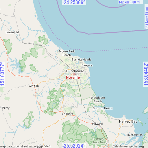
Norville GPS coordinates[2]
24° 53' 35.16" South, 152° 20' 27.204" East
| Map corner | latitude | longitude |
|---|---|---|
| Upper-left | -24.25366°, | 151.63777° |
| Center: | -24.8931°, | 152.34089° |
| Lower-right: | -25.52924°, | 153.04402° |
| Map W x H: | 141.8×141.8 km | = 88.1×88.1mi |
| max Lat: | -10.58257° ⇑10.2% North |
| Norville: | -24.8931° |
| min Lat: | ⇓89.8% South -43.31423° |
| min Long | Norville | max Long |
| 113.53327° | 152.34089° | 153.61246° |
| W 83.7%⇐ | ⇒16.3% E |
Elevation
Elevation of Norville is 28 m = 92 ft, and this is 94 m = 308 ft below average elevation for this country.
| Max E: |
1715 m = 5627 ft | 63.7% |
| Avg. | 122 m = 400 ft | |
| Norville | 28 m = 92 ft | |
Min E: |
-2 m = -7 ft | 36.3% |
See also: Australia elevation on elevation.city.
Geographical zone
Norville is located in South temperate zone (between Tropic of Capricorn and the Antarctic Circle). Distance of this Southern Tropic circle is 161.9 km =100.6 mi to North.| Distance of | km | miles | from Norville |
|---|---|---|---|
| Equator | 2767.9 | 1719.9 | to North |
| Tropic Capricorn | 161.9 | 100.6 | to North |
| Antarctic Circle | 4633.3 | 2879 | to South |
| South Pole | 7239.2 | 4498.2 | to South |


Nearby cities:
15 places around Norville: (largest is in red/bold)
• Ashfield
6 km =3.7 mi,  67°
67°
• Avenell Heights
2.7 km =1.7 mi,  81°
81°
• Avoca
3.7 km =2.3 mi,  296°
296°
• Bundaberg
3.1 km =1.9 mi,  13°
13°
• Bundaberg East
5.5 km =3.4 mi,  45°
45°
• Bundaberg North
4.9 km =3 mi, 6°
• Bundaberg South
3 km =1.9 mi,  40°
40°
• Bundaberg West
2.3 km =1.4 mi,  348°
348°
• Kalkie
7 km =4.3 mi, 39°
• Kensington
3.5 km =2.2 mi,  220°
220°
• Kepnock
3.9 km =2.4 mi,  61°
61°
• Millbank
2.7 km =1.7 mi,  316°
316°
• Svensson Heights
1.2 km =0.7 mi,  312°
312°
• Thabeban
1.2 km =0.7 mi,  129°
129°
• Walkervale
2.2 km =1.4 mi, 57°
Sources, notices
• [Note1] Compared only with cities in Australia existing in our database
• [Src1] Map data: © OpenStreetMap contributors (CC-BY-SA)
• [Src2] Other city data from geonames.org with taken over terms of usage.
• [Src3] Geographical zone / Annual Mean Temperature by Robert A. Rohde @ Wikipedia
