Minchinbury geodata
Minchinbury (New South Wales) is a section of populated place; located in Australia in Australia/Sydney (GMT+11) time zone. With population of 5,627 people, there are 1306 cities with bigger population in this country. Compared to other cities in Australia, 51.5% of cities are located further ↑North; 63.2% of cities are located further ←West and 63% of cities have lower elevation than Minchinbury. Note1


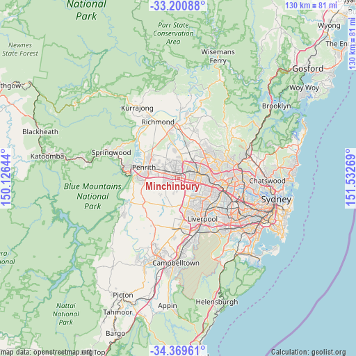
Minchinbury GPS coordinates[2]
33° 47' 14.064" South, 150° 49' 46.416" East
| Map corner | latitude | longitude |
|---|---|---|
| Upper-left | -33.20088°, | 150.12644° |
| Center: | -33.78724°, | 150.82956° |
| Lower-right: | -34.36961°, | 151.53269° |
| Map W x H: | 130×130 km | = 80.8×80.8mi |
| max Lat: | -10.58257° ⇑51.5% North |
| Minchinbury: | -33.78724° |
| min Lat: | ⇓48.5% South -43.31423° |
| min Long | Minchinbury | max Long |
| 113.53327° | 150.82956° | 153.61246° |
| W 63.2%⇐ | ⇒36.8% E |
Elevation
Elevation of Minchinbury is 73 m = 240 ft, and this is 49 m = 161 ft below average elevation for this country.
| Max E: |
1715 m = 5627 ft | 37% |
| Avg. | 122 m = 400 ft | |
| Minchinbury | 73 m = 240 ft | |
Min E: |
-2 m = -7 ft | 63% |
See also: Australia elevation on elevation.city.
Geographical zone
Minchinbury is located in South temperate zone (between Tropic of Capricorn and the Antarctic Circle). Distance of this Southern Tropic circle is 1150.9 km =715.1 mi to North.| Distance of | km | miles | from Minchinbury |
|---|---|---|---|
| Equator | 3756.8 | 2334.4 | to North |
| Tropic Capricorn | 1150.9 | 715.1 | to North |
| Antarctic Circle | 3644.4 | 2264.5 | to South |
| South Pole | 6250.3 | 3883.8 | to South |


Nearby cities:
15 places around Minchinbury: (largest is in red/bold)
• Bungarribee
3.7 km =2.3 mi,  72°
72°
• Colyton
3.1 km =1.9 mi,  279°
279°
• Dharruk
4.5 km =2.8 mi,  343°
343°
• Doonside
4.1 km =2.5 mi,  56°
56°
• Eastern Creek
3.6 km =2.2 mi,  125°
125°
• Emerton
5.3 km =3.3 mi, 335°
• Erskine Park
4.1 km =2.5 mi,  225°
225°
• Glendenning
4.9 km =3 mi,  27°
27°
• Hebersham
4.6 km =2.9 mi,  353°
353°
• Mount Druitt
2.6 km =1.6 mi,  332°
332°
• Oxley Park
3.7 km =2.3 mi,  299°
299°
• Plumpton
4 km =2.5 mi,  9°
9°
• Rooty Hill
2.3 km =1.4 mi, 8°
• St Clair
4.3 km =2.7 mi,  254°
254°
• Whalan
4.1 km =2.5 mi,  324°
324°
Sources, notices
• [Note1] Compared only with cities in Australia existing in our database
• [Src1] Map data: © OpenStreetMap contributors (CC-BY-SA)
• [Src2] Other city data from geonames.org with taken over terms of usage.
• [Src3] Geographical zone / Annual Mean Temperature by Robert A. Rohde @ Wikipedia
