Narrawallee geodata
Narrawallee (New South Wales) is a section of populated place; located in Australia in Australia/Sydney (GMT+11) time zone. With population of 1,235 people, there are 3536 cities with bigger population in this country. Compared to other cities in Australia, 75.5% of cities are located further ↑North; 58.4% of cities are located further ←West and 60% of cities have higher elevation than Narrawallee. Note1


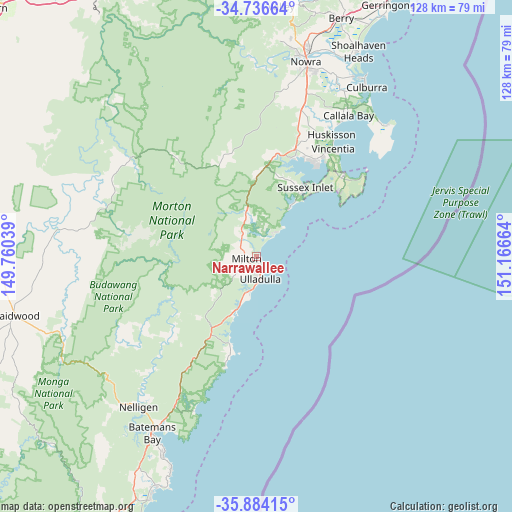
Narrawallee GPS coordinates[2]
35° 18' 44.748" South, 150° 27' 48.636" East
| Map corner | latitude | longitude |
|---|---|---|
| Upper-left | -34.73664°, | 149.76039° |
| Center: | -35.31243°, | 150.46351° |
| Lower-right: | -35.88415°, | 151.16664° |
| Map W x H: | 127.6×127.6 km | = 79.3×79.3mi |
| max Lat: | -10.58257° ⇑75.5% North |
| Narrawallee: | -35.31243° |
| min Lat: | ⇓24.5% South -43.31423° |
| min Long | Narrawallee | max Long |
| 113.53327° | 150.46351° | 153.61246° |
| W 58.4%⇐ | ⇒41.6% E |
Elevation
Elevation of Narrawallee is 32 m = 105 ft, and this is 90 m = 295 ft below average elevation for this country.
| Max E: |
1715 m = 5627 ft | 60% |
| Avg. | 122 m = 400 ft | |
| Narrawallee | 32 m = 105 ft | |
Min E: |
-2 m = -7 ft | 40% |
See also: Australia elevation on elevation.city.
Geographical zone
Narrawallee is located in South temperate zone (between Tropic of Capricorn and the Antarctic Circle). Distance of this Southern Tropic circle is 1320.5 km =820.5 mi to North.| Distance of | km | miles | from Narrawallee |
|---|---|---|---|
| Equator | 3926.4 | 2439.8 | to North |
| Tropic Capricorn | 1320.5 | 820.5 | to North |
| Antarctic Circle | 3474.8 | 2159.1 | to South |
| South Pole | 6080.7 | 3778.4 | to South |


Nearby cities:
15 places around Narrawallee: (largest is in red/bold)
• Basin View
26.3 km =16.3 mi,  18°
18°
• Bawley Point
23.4 km =14.5 mi,  195°
195°
• Burrill Lake
8.4 km =5.2 mi,  188°
188°
• Erowal Bay
29.1 km =18.1 mi,  35°
35°
• Jervis Bay Village
30 km =18.6 mi,  46°
46°
• Kings Point
6.9 km =4.3 mi, 202°
• Lake Tabourie
15.3 km =9.5 mi, 202°
• Manyana
7.9 km =4.9 mi, 39°
• Milton
2.5 km =1.6 mi,  259°
259°
• Mollymook
3.2 km =2 mi,  170°
170°
• Mollymook Beach
2.1 km =1.3 mi,  158°
158°
• Sanctuary Point
27.5 km =17.1 mi,  32°
32°
• St. Georges Basin
27.6 km =17.1 mi, 26°
• Sussex Inlet
20.5 km =12.7 mi, 32°
• Ulladulla
5.2 km =3.2 mi, 171°
Sources, notices
• [Note1] Compared only with cities in Australia existing in our database
• [Src1] Map data: © OpenStreetMap contributors (CC-BY-SA)
• [Src2] Other city data from geonames.org with taken over terms of usage.
• [Src3] Geographical zone / Annual Mean Temperature by Robert A. Rohde @ Wikipedia
