Manyana geodata
Manyana (New South Wales) is a populated place; located in Australia in Australia/Sydney (GMT+11) time zone. With population of 503 people, there are 4871 cities with bigger population in this country. Compared to other cities in Australia, 75.1% of cities are located further ↑North; 58.9% of cities are located further ←West and 63.7% of cities have higher elevation than Manyana. Note1


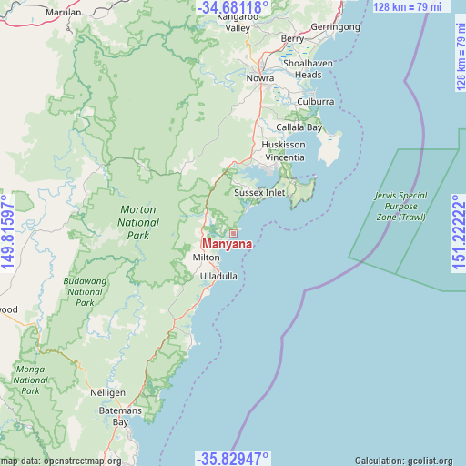
Manyana GPS coordinates[2]
35° 15' 26.496" South, 150° 31' 8.724" East
| Map corner | latitude | longitude |
|---|---|---|
| Upper-left | -34.68118°, | 149.81597° |
| Center: | -35.25736°, | 150.51909° |
| Lower-right: | -35.82947°, | 151.22222° |
| Map W x H: | 127.7×127.7 km | = 79.3×79.3mi |
| max Lat: | -10.58257° ⇑75.1% North |
| Manyana: | -35.25736° |
| min Lat: | ⇓24.9% South -43.31423° |
| min Long | Manyana | max Long |
| 113.53327° | 150.51909° | 153.61246° |
| W 58.9%⇐ | ⇒41.1% E |
Elevation
Elevation of Manyana is 28 m = 92 ft, and this is 94 m = 308 ft below average elevation for this country.
| Max E: |
1715 m = 5627 ft | 63.7% |
| Avg. | 122 m = 400 ft | |
| Manyana | 28 m = 92 ft | |
Min E: |
-2 m = -7 ft | 36.3% |
See also: Australia elevation on elevation.city.
Geographical zone
Manyana is located in South temperate zone (between Tropic of Capricorn and the Antarctic Circle). Distance of this Southern Tropic circle is 1314.3 km =816.7 mi to North.| Distance of | km | miles | from Manyana |
|---|---|---|---|
| Equator | 3920.3 | 2436 | to North |
| Tropic Capricorn | 1314.3 | 816.7 | to North |
| Antarctic Circle | 3480.9 | 2162.9 | to South |
| South Pole | 6086.8 | 3782.2 | to South |


Nearby cities:
15 places around Manyana: (largest is in red/bold)
• Basin View
19.1 km =11.9 mi,  9°
9°
• Burrill Lake
15.8 km =9.8 mi,  203°
203°
• Erowal Bay
21.2 km =13.2 mi,  34°
34°
• Jervis Bay Village
22.1 km =13.7 mi,  49°
49°
• Kings Point
14.7 km =9.1 mi,  211°
211°
• Lake Tabourie
23 km =14.3 mi, 208°
• Milton
10 km =6.2 mi,  228°
228°
• Mollymook
10.3 km =6.4 mi, 205°
• Mollymook Beach
9.1 km =5.7 mi, 208°
• Narrawallee
7.9 km =4.9 mi,  219°
219°
• Old Erowal Bay
22.4 km =13.9 mi, 30°
• Sanctuary Point
19.7 km =12.2 mi, 29°
• St. Georges Basin
20 km =12.4 mi,  21°
21°
• Sussex Inlet
12.7 km =7.9 mi, 28°
• Ulladulla
12.1 km =7.5 mi, 200°
Sources, notices
• [Note1] Compared only with cities in Australia existing in our database
• [Src1] Map data: © OpenStreetMap contributors (CC-BY-SA)
• [Src2] Other city data from geonames.org with taken over terms of usage.
• [Src3] Geographical zone / Annual Mean Temperature by Robert A. Rohde @ Wikipedia
