Viveash geodata
Viveash (Western Australia) is a section of populated place; located in Australia in Australia/Perth (GMT+8) time zone. With population of 1,021 people, there are 3791 cities with bigger population in this country. Compared to other cities in Australia, 67.2% of cities are located further ↓South; 92.5% of cities are located further →East and 100% of cities have higher elevation than Viveash. Note1


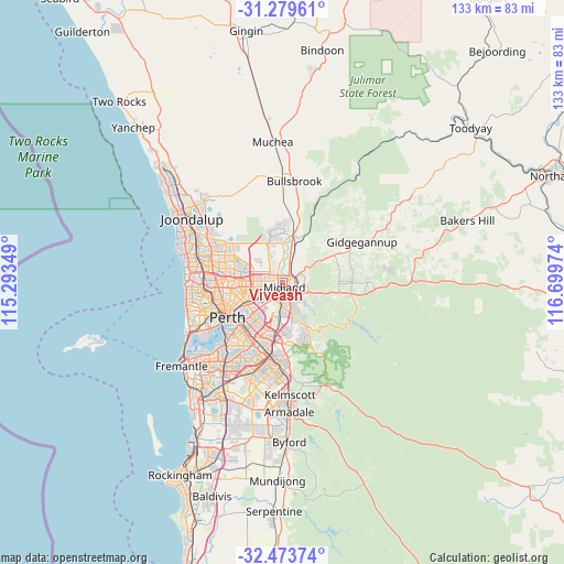
Viveash GPS coordinates[2]
31° 52' 42.996" South, 115° 59' 47.796" East
| Map corner | latitude | longitude |
|---|---|---|
| Upper-left | -31.27961°, | 115.29349° |
| Center: | -31.87861°, | 115.99661° |
| Lower-right: | -32.47374°, | 116.69974° |
| Map W x H: | 132.8×132.8 km | = 82.5×82.5mi |
| max Lat: | -10.58257° ⇑32.8% North |
| Viveash: | -31.87861° |
| min Lat: | ⇓67.2% South -43.31423° |
| min Long | Viveash | max Long |
| 113.53327° | 115.99661° | 153.61246° |
| W 7.5%⇐ | ⇒92.5% E |
Elevation
Elevation of Viveash is 0 m = 0 ft, and this is 122 m = 400 ft below average elevation for this country.
| Max E: |
1715 m = 5627 ft | 100% |
| Avg. | 122 m = 400 ft | |
| Viveash | 0 m = 0 ft | |
Min E: |
-2 m = -7 ft | 0% |
See also: Australia elevation on elevation.city.
Geographical zone
Viveash is located in South temperate zone (between Tropic of Capricorn and the Antarctic Circle). Distance of this Southern Tropic circle is 938.7 km =583.3 mi to North.| Distance of | km | miles | from Viveash |
|---|---|---|---|
| Equator | 3544.6 | 2202.5 | to North |
| Tropic Capricorn | 938.7 | 583.3 | to North |
| Antarctic Circle | 3856.6 | 2396.4 | to South |
| South Pole | 6462.5 | 4015.6 | to South |


Nearby cities:
15 places around Viveash: (largest is in red/bold)
• Bellevue
3.9 km =2.4 mi,  130°
130°
• Caversham
2.9 km =1.8 mi,  259°
259°
• Dayton
3.6 km =2.2 mi,  324°
324°
• Eden Hill
4.8 km =3 mi, 256°
• Guildford
3.7 km =2.3 mi,  229°
229°
• Hazelmere
4.5 km =2.8 mi,  161°
161°
• Lockridge
4.4 km =2.7 mi,  265°
265°
• Middle Swan
3.7 km =2.3 mi,  30°
30°
• Midland
1.8 km =1.1 mi, 131°
• Midvale
3.6 km =2.2 mi,  108°
108°
• South Guildford
4.6 km =2.9 mi,  215°
215°
• Stratton
4.3 km =2.7 mi,  74°
74°
• Swan View
5.1 km =3.2 mi,  95°
95°
• West Swan
3.8 km =2.4 mi,  335°
335°
• Woodbridge
1 km =0.6 mi,  205°
205°
Sources, notices
• [Note1] Compared only with cities in Australia existing in our database
• [Src1] Map data: © OpenStreetMap contributors (CC-BY-SA)
• [Src2] Other city data from geonames.org with taken over terms of usage.
• [Src3] Geographical zone / Annual Mean Temperature by Robert A. Rohde @ Wikipedia
