Lockridge geodata
Lockridge (Western Australia) is a section of populated place; located in Australia in Australia/Perth (GMT+8) time zone. With population of 3,390 people, there are 2031 cities with bigger population in this country. Compared to other cities in Australia, 67.1% of cities are located further ↓South; 93.1% of cities are located further →East and 65.9% of cities have higher elevation than Lockridge. Note1


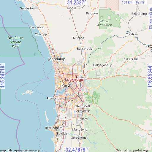
Lockridge GPS coordinates[2]
31° 52' 54.048" South, 115° 57' 1.116" East
| Map corner | latitude | longitude |
|---|---|---|
| Upper-left | -31.2827°, | 115.24719° |
| Center: | -31.88168°, | 115.95031° |
| Lower-right: | -32.47679°, | 116.65344° |
| Map W x H: | 132.8×132.8 km | = 82.5×82.5mi |
| max Lat: | -10.58257° ⇑32.9% North |
| Lockridge: | -31.88168° |
| min Lat: | ⇓67.1% South -43.31423° |
| min Long | Lockridge | max Long |
| 113.53327° | 115.95031° | 153.61246° |
| W 6.9%⇐ | ⇒93.1% E |
Elevation
Elevation of Lockridge is 26 m = 85 ft, and this is 96 m = 315 ft below average elevation for this country.
| Max E: |
1715 m = 5627 ft | 65.9% |
| Avg. | 122 m = 400 ft | |
| Lockridge | 26 m = 85 ft | |
Min E: |
-2 m = -7 ft | 34.1% |
See also: Australia elevation on elevation.city.
Geographical zone
Lockridge is located in South temperate zone (between Tropic of Capricorn and the Antarctic Circle). Distance of this Southern Tropic circle is 939 km =583.5 mi to North.| Distance of | km | miles | from Lockridge |
|---|---|---|---|
| Equator | 3544.9 | 2202.7 | to North |
| Tropic Capricorn | 939 | 583.5 | to North |
| Antarctic Circle | 3856.3 | 2396.2 | to South |
| South Pole | 6462.2 | 4015.4 | to South |


Nearby cities:
15 places around Lockridge: (largest is in red/bold)
• Ashfield
4.1 km =2.5 mi,  196°
196°
• Bassendean
3.1 km =1.9 mi,  191°
191°
• Beechboro
2.2 km =1.4 mi,  324°
324°
• Bennett Springs
2.5 km =1.6 mi,  348°
348°
• Caversham
1.6 km =1 mi,  96°
96°
• Dayton
4 km =2.5 mi,  35°
35°
• Eden Hill
0.9 km =0.6 mi, 202°
• Embleton
4.6 km =2.9 mi,  238°
238°
• Guildford
2.6 km =1.6 mi,  142°
142°
• Kiara
1.1 km =0.7 mi,  270°
270°
• Morley
3.9 km =2.4 mi,  259°
259°
• South Guildford
3.8 km =2.4 mi,  153°
153°
• Viveash
4.4 km =2.7 mi,  85°
85°
• West Swan
4.7 km =2.9 mi, 36°
• Woodbridge
4 km =2.5 mi, 98°
Sources, notices
• [Note1] Compared only with cities in Australia existing in our database
• [Src1] Map data: © OpenStreetMap contributors (CC-BY-SA)
• [Src2] Other city data from geonames.org with taken over terms of usage.
• [Src3] Geographical zone / Annual Mean Temperature by Robert A. Rohde @ Wikipedia
