Branyan geodata
Branyan (Queensland) is a section of populated place; located in Australia in Australia/Brisbane (GMT+10) time zone. With population of 3,985 people, there are 1792 cities with bigger population in this country. Compared to other cities in Australia, 89.8% of cities are located further ↓South; 83.4% of cities are located further ←West and 61.8% of cities have higher elevation than Branyan. Note1


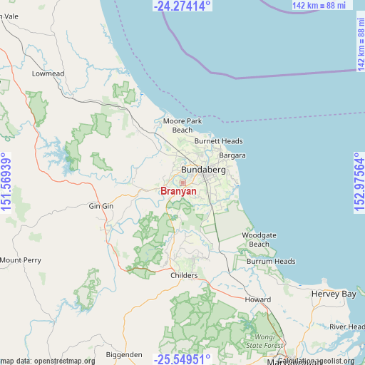
Branyan GPS coordinates[2]
24° 54' 48.492" South, 152° 16' 21.036" East
| Map corner | latitude | longitude |
|---|---|---|
| Upper-left | -24.27414°, | 151.56939° |
| Center: | -24.91347°, | 152.27251° |
| Lower-right: | -25.54951°, | 152.97564° |
| Map W x H: | 141.8×141.8 km | = 88.1×88.1mi |
| max Lat: | -10.58257° ⇑10.2% North |
| Branyan: | -24.91347° |
| min Lat: | ⇓89.8% South -43.31423° |
| min Long | Branyan | max Long |
| 113.53327° | 152.27251° | 153.61246° |
| W 83.4%⇐ | ⇒16.6% E |
Elevation
Elevation of Branyan is 30 m = 98 ft, and this is 92 m = 302 ft below average elevation for this country.
| Max E: |
1715 m = 5627 ft | 61.8% |
| Avg. | 122 m = 400 ft | |
| Branyan | 30 m = 98 ft | |
Min E: |
-2 m = -7 ft | 38.2% |
See also: Australia elevation on elevation.city.
Geographical zone
Branyan is located in South temperate zone (between Tropic of Capricorn and the Antarctic Circle). Distance of this Southern Tropic circle is 164.2 km =102 mi to North.| Distance of | km | miles | from Branyan |
|---|---|---|---|
| Equator | 2770.1 | 1721.3 | to North |
| Tropic Capricorn | 164.2 | 102 | to North |
| Antarctic Circle | 4631.1 | 2877.6 | to South |
| South Pole | 7236.9 | 4496.8 | to South |


Nearby cities:
15 places around Branyan: (largest is in red/bold)
• Avenell Heights
10 km =6.2 mi,  74°
74°
• Avoca
5.3 km =3.3 mi,  42°
42°
• Bundaberg
9.2 km =5.7 mi,  55°
55°
• Bundaberg North
10.3 km =6.4 mi,  46°
46°
• Bundaberg South
9.9 km =6.2 mi, 62°
• Bundaberg West
7.9 km =4.9 mi, 54°
• Kensington
4.6 km =2.9 mi,  95°
95°
• Millbank
6.6 km =4.1 mi, 49°
• Norville
7.3 km =4.5 mi, 71°
• Sharon
4.2 km =2.6 mi,  356°
356°
• South Bingera
7.8 km =4.8 mi,  219°
219°
• South Kolan
10.7 km =6.6 mi,  258°
258°
• Svensson Heights
6.7 km =4.2 mi, 62°
• Thabeban
8 km =5 mi,  79°
79°
• Walkervale
9.4 km =5.8 mi, 68°
Sources, notices
• [Note1] Compared only with cities in Australia existing in our database
• [Src1] Map data: © OpenStreetMap contributors (CC-BY-SA)
• [Src2] Other city data from geonames.org with taken over terms of usage.
• [Src3] Geographical zone / Annual Mean Temperature by Robert A. Rohde @ Wikipedia
