Viewbank geodata
Viewbank (Victoria) is a section of populated place; located in Australia in Australia/Melbourne (GMT+11) time zone. With population of 6,769 people, there are 1015 cities with bigger population in this country. Compared to other cities in Australia, 85.8% of cities are located further ↑North; 64.6% of cities are located further →East and 52% of cities have lower elevation than Viewbank. Note1


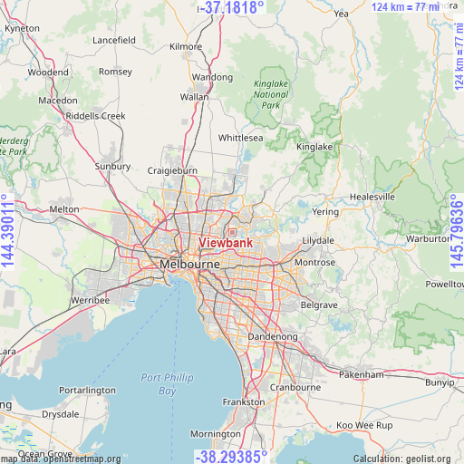
Viewbank GPS coordinates[2]
37° 44' 23.676" South, 145° 5' 35.628" East
| Map corner | latitude | longitude |
|---|---|---|
| Upper-left | -37.1818°, | 144.39011° |
| Center: | -37.73991°, | 145.09323° |
| Lower-right: | -38.29385°, | 145.79636° |
| Map W x H: | 123.6×123.6 km | = 76.8×76.8mi |
| max Lat: | -10.58257° ⇑85.8% North |
| Viewbank: | -37.73991° |
| min Lat: | ⇓14.2% South -43.31423° |
| min Long | Viewbank | max Long |
| 113.53327° | 145.09323° | 153.61246° |
| W 35.4%⇐ | ⇒64.6% E |
Elevation
Elevation of Viewbank is 48 m = 157 ft, and this is 74 m = 243 ft below average elevation for this country.
| Max E: |
1715 m = 5627 ft | 48% |
| Avg. | 122 m = 400 ft | |
| Viewbank | 48 m = 157 ft | |
Min E: |
-2 m = -7 ft | 52% |
See also: Australia elevation on elevation.city.
Geographical zone
Viewbank is located in South temperate zone (between Tropic of Capricorn and the Antarctic Circle). Distance of this Southern Tropic circle is 1590.4 km =988.2 mi to North.| Distance of | km | miles | from Viewbank |
|---|---|---|---|
| Equator | 4196.3 | 2607.5 | to North |
| Tropic Capricorn | 1590.4 | 988.2 | to North |
| Antarctic Circle | 3204.9 | 1991.4 | to South |
| South Pole | 5810.8 | 3610.7 | to South |


Nearby cities:
15 places around Viewbank: (largest is in red/bold)
• Briar Hill
4.5 km =2.8 mi,  33°
33°
• Bulleen
3.1 km =1.9 mi,  196°
196°
• Eaglemont
3.7 km =2.3 mi,  224°
224°
• Greensborough
4 km =2.5 mi,  12°
12°
• Heidelberg
2.6 km =1.6 mi,  244°
244°
• Heidelberg Heights
3.2 km =2 mi,  263°
263°
• Ivanhoe East
4.6 km =2.9 mi, 216°
• Lower Plenty
2.2 km =1.4 mi,  70°
70°
• Macleod
2.4 km =1.5 mi,  287°
287°
• Montmorency
3.3 km =2.1 mi,  38°
38°
• Rosanna
2.3 km =1.4 mi,  272°
272°
• Templestowe Lower
3.6 km =2.2 mi,  145°
145°
• Watsonia
2.7 km =1.7 mi,  341°
341°
• Watsonia North
4.5 km =2.8 mi,  350°
350°
• Yallambie
1.6 km =1 mi,  0°
0°
Sources, notices
• [Note1] Compared only with cities in Australia existing in our database
• [Src1] Map data: © OpenStreetMap contributors (CC-BY-SA)
• [Src2] Other city data from geonames.org with taken over terms of usage.
• [Src3] Geographical zone / Annual Mean Temperature by Robert A. Rohde @ Wikipedia
