Yallambie geodata
Yallambie (Victoria) is a section of populated place; located in Australia in Australia/Melbourne (GMT+11) time zone. With population of 4,162 people, there are 1736 cities with bigger population in this country. Compared to other cities in Australia, 85.4% of cities are located further ↑North; 64.6% of cities are located further →East and 64.4% of cities have lower elevation than Yallambie. Note1


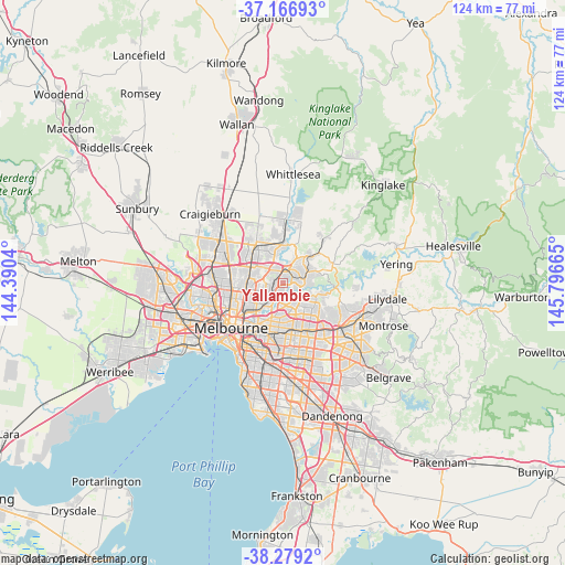
Yallambie GPS coordinates[2]
37° 43' 30.54" South, 145° 5' 36.672" East
| Map corner | latitude | longitude |
|---|---|---|
| Upper-left | -37.16693°, | 144.3904° |
| Center: | -37.72515°, | 145.09352° |
| Lower-right: | -38.2792°, | 145.79665° |
| Map W x H: | 123.7×123.7 km | = 76.9×76.9mi |
| max Lat: | -10.58257° ⇑85.4% North |
| Yallambie: | -37.72515° |
| min Lat: | ⇓14.6% South -43.31423° |
| min Long | Yallambie | max Long |
| 113.53327° | 145.09352° | 153.61246° |
| W 35.4%⇐ | ⇒64.6% E |
Elevation
Elevation of Yallambie is 78 m = 256 ft, and this is 44 m = 144 ft below average elevation for this country.
| Max E: |
1715 m = 5627 ft | 35.6% |
| Avg. | 122 m = 400 ft | |
| Yallambie | 78 m = 256 ft | |
Min E: |
-2 m = -7 ft | 64.4% |
See also: Australia elevation on elevation.city.
Geographical zone
Yallambie is located in South temperate zone (between Tropic of Capricorn and the Antarctic Circle). Distance of this Southern Tropic circle is 1588.7 km =987.2 mi to North.| Distance of | km | miles | from Yallambie |
|---|---|---|---|
| Equator | 4194.6 | 2606.4 | to North |
| Tropic Capricorn | 1588.7 | 987.2 | to North |
| Antarctic Circle | 3206.5 | 1992.4 | to South |
| South Pole | 5812.4 | 3611.7 | to South |


Nearby cities:
15 places around Yallambie: (largest is in red/bold)
• Briar Hill
3.2 km =2 mi,  49°
49°
• Bulleen
4.7 km =2.9 mi,  190°
190°
• Bundoora
4.2 km =2.6 mi,  315°
315°
• Greensborough
2.4 km =1.5 mi,  20°
20°
• Heidelberg
3.6 km =2.2 mi,  220°
220°
• Heidelberg Heights
3.8 km =2.4 mi,  238°
238°
• Lower Plenty
2.2 km =1.4 mi,  114°
114°
• Macleod
2.5 km =1.6 mi,  248°
248°
• Montmorency
2.2 km =1.4 mi,  65°
65°
• Rosanna
2.8 km =1.7 mi, 236°
• Saint Helena
4.5 km =2.8 mi, 51°
• St Helena
4.7 km =2.9 mi,  33°
33°
• Viewbank
1.6 km =1 mi,  180°
180°
• Watsonia
1.3 km =0.8 mi, 316°
• Watsonia North
2.9 km =1.8 mi,  344°
344°
Sources, notices
• [Note1] Compared only with cities in Australia existing in our database
• [Src1] Map data: © OpenStreetMap contributors (CC-BY-SA)
• [Src2] Other city data from geonames.org with taken over terms of usage.
• [Src3] Geographical zone / Annual Mean Temperature by Robert A. Rohde @ Wikipedia
