Brookwater geodata
Brookwater (Queensland) is a section of populated place; located in Australia in Australia/Brisbane (GMT+10) time zone. With population of 2,119 people, there are 2812 cities with bigger population in this country. Compared to other cities in Australia, 78.2% of cities are located further ↓South; 88.5% of cities are located further ←West and 65.3% of cities have lower elevation than Brookwater. Note1


Brookwater GPS coordinates[2]
27° 39' 40.608" South, 152° 53' 48.084" East
| Map corner | latitude | longitude |
|---|---|---|
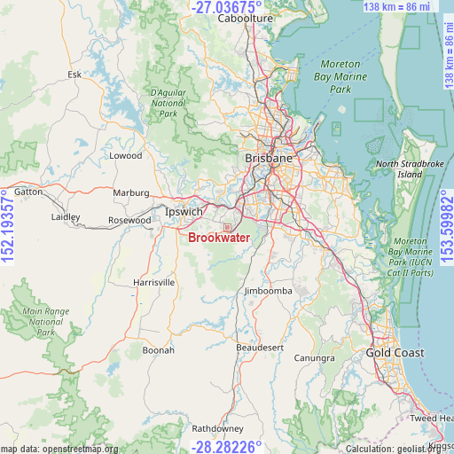
| Upper-left | -27.03675°, | 152.19357° |
| Center: | -27.66128°, | 152.89669° |
| Lower-right: | -28.28226°, | 153.59982° |
| Map W x H: | 138.5×138.5 km | = 86.1×86.1mi |
| max Lat: | -10.58257° ⇑21.8% North |
| Brookwater: | -27.66128° |
| min Lat: | ⇓78.2% South -43.31423° |
| min Long | Brookwater | max Long |
| 113.53327° | 152.89669° | 153.61246° |
| W 88.5%⇐ | ⇒11.5% E |
Elevation
Elevation of Brookwater is 81 m = 266 ft, and this is 41 m = 135 ft below average elevation for this country.
| Max E: |
1715 m = 5627 ft | 34.7% |
| Avg. | 122 m = 400 ft | |
| Brookwater | 81 m = 266 ft | |
Min E: |
-2 m = -7 ft | 65.3% |
See also: Australia elevation on elevation.city.
Geographical zone
Brookwater is located in South temperate zone (between Tropic of Capricorn and the Antarctic Circle). Distance of this Southern Tropic circle is 469.7 km =291.9 mi to North.| Distance of | km | miles | from Brookwater |
|---|---|---|---|
| Equator | 3075.6 | 1911.1 | to North |
| Tropic Capricorn | 469.7 | 291.9 | to North |
| Antarctic Circle | 4325.5 | 2687.7 | to South |
| South Pole | 6931.4 | 4307 | to South |


Nearby cities:
15 places around Brookwater: (largest is in red/bold)
• Augustine Heights
1.7 km =1.1 mi,  272°
272°
• Bellbird Park
2.9 km =1.8 mi,  340°
340°
• Camira
3.8 km =2.4 mi,  38°
38°
• Collingwood Park
6.5 km =4 mi,  326°
326°
• Ellen Grove
6.9 km =4.3 mi, 42°
• Forest Lake
8.1 km =5 mi,  60°
60°
• Gailes
5.8 km =3.6 mi,  16°
16°
• Goodna
5.7 km =3.5 mi,  2°
2°
• Redbank
7.4 km =4.6 mi, 336°
• Redbank Plains
4 km =2.5 mi,  294°
294°
• Richlands
9.1 km =5.7 mi, 37°
• Ripley
8.8 km =5.5 mi,  225°
225°
• Riverview
8.2 km =5.1 mi, 325°
• Springfield
2.2 km =1.4 mi,  67°
67°
• Springfield Lakes
2.9 km =1.8 mi,  104°
104°
Sources, notices
• [Note1] Compared only with cities in Australia existing in our database
• [Src1] Map data: © OpenStreetMap contributors (CC-BY-SA)
• [Src2] Other city data from geonames.org with taken over terms of usage.
• [Src3] Geographical zone / Annual Mean Temperature by Robert A. Rohde @ Wikipedia
