Richlands geodata
Richlands (Queensland) is a section of populated place; located in Australia in Australia/Brisbane (GMT+10) time zone. With population of 3,544 people, there are 1978 cities with bigger population in this country. Compared to other cities in Australia, 79.7% of cities are located further ↓South; 89.7% of cities are located further ←West and 54% of cities have lower elevation than Richlands. Note1


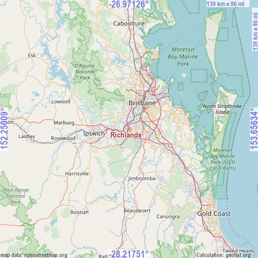
Richlands GPS coordinates[2]
27° 35' 46.176" South, 152° 57' 11.556" East
| Map corner | latitude | longitude |
|---|---|---|
| Upper-left | -26.97126°, | 152.25009° |
| Center: | -27.59616°, | 152.95321° |
| Lower-right: | -28.21751°, | 153.65634° |
| Map W x H: | 138.6×138.6 km | = 86.1×86.1mi |
| max Lat: | -10.58257° ⇑20.3% North |
| Richlands: | -27.59616° |
| min Lat: | ⇓79.7% South -43.31423° |
| min Long | Richlands | max Long |
| 113.53327° | 152.95321° | 153.61246° |
| W 89.7%⇐ | ⇒10.3% E |
Elevation
Elevation of Richlands is 51 m = 167 ft, and this is 71 m = 233 ft below average elevation for this country.
| Max E: |
1715 m = 5627 ft | 46% |
| Avg. | 122 m = 400 ft | |
| Richlands | 51 m = 167 ft | |
Min E: |
-2 m = -7 ft | 54% |
See also: Australia elevation on elevation.city.
Geographical zone
Richlands is located in South temperate zone (between Tropic of Capricorn and the Antarctic Circle). Distance of this Southern Tropic circle is 462.5 km =287.4 mi to North.| Distance of | km | miles | from Richlands |
|---|---|---|---|
| Equator | 3068.4 | 1906.6 | to North |
| Tropic Capricorn | 462.5 | 287.4 | to North |
| Antarctic Circle | 4332.8 | 2692.3 | to South |
| South Pole | 6938.7 | 4311.5 | to South |


Nearby cities:
15 places around Richlands: (largest is in red/bold)
• Camira
5.3 km =3.3 mi,  216°
216°
• Darra
3.3 km =2.1 mi,  1°
1°
• Doolandella
3.7 km =2.3 mi,  120°
120°
• Durack
3.3 km =2.1 mi,  76°
76°
• Ellen Grove
2.3 km =1.4 mi,  203°
203°
• Forest Lake
3.6 km =2.2 mi,  154°
154°
• Gailes
4.3 km =2.7 mi,  246°
246°
• Goodna
5.6 km =3.5 mi, 253°
• Heathwood
5.5 km =3.4 mi,  141°
141°
• Inala
2.1 km =1.3 mi,  93°
93°
• Jamboree Heights
4.8 km =3 mi,  336°
336°
• Middle Park
5.4 km =3.4 mi,  325°
325°
• Seventeen Mile Rocks
5.1 km =3.2 mi,  6°
6°
• Sumner
3.9 km =2.4 mi, 330°
• Wacol
2.4 km =1.5 mi,  306°
306°
Sources, notices
• [Note1] Compared only with cities in Australia existing in our database
• [Src1] Map data: © OpenStreetMap contributors (CC-BY-SA)
• [Src2] Other city data from geonames.org with taken over terms of usage.
• [Src3] Geographical zone / Annual Mean Temperature by Robert A. Rohde @ Wikipedia
