Meadowbrook geodata
Meadowbrook (Queensland) is a section of populated place; located in Australia in Australia/Brisbane (GMT+10) time zone. With population of 3,199 people, there are 2129 cities with bigger population in this country. Compared to other cities in Australia, 78.1% of cities are located further ↓South; 96% of cities are located further ←West and 85% of cities have higher elevation than Meadowbrook. Note1


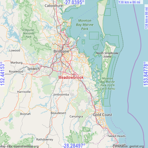
Meadowbrook GPS coordinates[2]
27° 39' 50.436" South, 153° 8' 40.74" East
| Map corner | latitude | longitude |
|---|---|---|
| Upper-left | -27.0395°, | 152.44153° |
| Center: | -27.66401°, | 153.14465° |
| Lower-right: | -28.28497°, | 153.84778° |
| Map W x H: | 138.5×138.5 km | = 86.1×86.1mi |
| max Lat: | -10.58257° ⇑21.9% North |
| Meadowbrook: | -27.66401° |
| min Lat: | ⇓78.1% South -43.31423° |
| min Long | Meadowbrook | max Long |
| 113.53327° | 153.14465° | 153.61246° |
| W 96%⇐ | ⇒4% E |
Elevation
Elevation of Meadowbrook is 12 m = 39 ft, and this is 110 m = 361 ft below average elevation for this country.
| Max E: |
1715 m = 5627 ft | 85% |
| Avg. | 122 m = 400 ft | |
| Meadowbrook | 12 m = 39 ft | |
Min E: |
-2 m = -7 ft | 15% |
See also: Australia elevation on elevation.city.
Geographical zone
Meadowbrook is located in South temperate zone (between Tropic of Capricorn and the Antarctic Circle). Distance of this Southern Tropic circle is 470 km =292 mi to North.| Distance of | km | miles | from Meadowbrook |
|---|---|---|---|
| Equator | 3075.9 | 1911.3 | to North |
| Tropic Capricorn | 470 | 292 | to North |
| Antarctic Circle | 4325.2 | 2687.6 | to South |
| South Pole | 6931.1 | 4306.8 | to South |


Nearby cities:
15 places around Meadowbrook: (largest is in red/bold)
• Daisy Hill
4 km =2.5 mi,  19°
19°
• Edens Landing
4.9 km =3 mi,  150°
150°
• Holmview
6.3 km =3.9 mi,  156°
156°
• Kingston
2.8 km =1.7 mi,  263°
263°
• Logan Central
4.3 km =2.7 mi,  301°
301°
• Logan City
4.4 km =2.7 mi,  308°
308°
• Loganholme
4.7 km =2.9 mi,  118°
118°
• Loganlea
1.6 km =1 mi,  217°
217°
• Marsden
4.8 km =3 mi, 257°
• Shailer Park
3.6 km =2.2 mi,  63°
63°
• Slacks Creek
1.6 km =1 mi, 18°
• Springwood
6 km =3.7 mi,  345°
345°
• Tanah Merah
2.6 km =1.6 mi,  108°
108°
• Waterford West
3.2 km =2 mi,  200°
200°
• Woodridge
5.6 km =3.5 mi, 307°
Sources, notices
• [Note1] Compared only with cities in Australia existing in our database
• [Src1] Map data: © OpenStreetMap contributors (CC-BY-SA)
• [Src2] Other city data from geonames.org with taken over terms of usage.
• [Src3] Geographical zone / Annual Mean Temperature by Robert A. Rohde @ Wikipedia
