Woodridge geodata
Woodridge (Queensland) is a populated place; located in Australia in Australia/Brisbane (GMT+10) time zone. With population of 12,425 people, there are 387 cities with bigger population in this country. Compared to other cities in Australia, 78.7% of cities are located further ↓South; 94.9% of cities are located further ←West and 53.7% of cities have higher elevation than Woodridge. Note1


Woodridge GPS coordinates[2]
27° 37' 59.988" South, 153° 6' 0" East
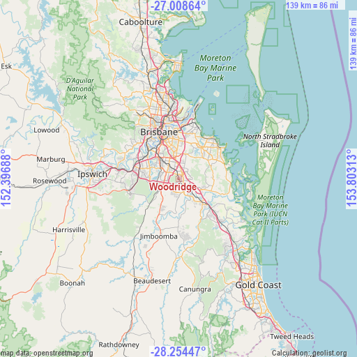
| Map corner | latitude | longitude |
|---|---|---|
| Upper-left | -27.00864°, | 152.39688° |
| Center: | -27.63333°, | 153.1° |
| Lower-right: | -28.25447°, | 153.80313° |
| Map W x H: | 138.5×138.5 km | = 86.1×86.1mi |
| max Lat: | -10.58257° ⇑21.3% North |
| Woodridge: | -27.63333° |
| min Lat: | ⇓78.7% South -43.31423° |
| min Long | Woodridge | max Long |
| 113.53327° | 153.1° | 153.61246° |
| W 94.9%⇐ | ⇒5.1% E |
Elevation
Elevation of Woodridge is 40 m = 131 ft, and this is 82 m = 269 ft below average elevation for this country.
| Max E: |
1715 m = 5627 ft | 53.7% |
| Avg. | 122 m = 400 ft | |
| Woodridge | 40 m = 131 ft | |
Min E: |
-2 m = -7 ft | 46.3% |
See also: Australia elevation on elevation.city.
Geographical zone
Woodridge is located in South temperate zone (between Tropic of Capricorn and the Antarctic Circle). Distance of this Southern Tropic circle is 466.6 km =289.9 mi to North.| Distance of | km | miles | from Woodridge |
|---|---|---|---|
| Equator | 3072.5 | 1909.2 | to North |
| Tropic Capricorn | 466.6 | 289.9 | to North |
| Antarctic Circle | 4328.6 | 2689.7 | to South |
| South Pole | 6934.5 | 4308.9 | to South |


Nearby cities:
15 places around Woodridge: (largest is in red/bold)
• Berrinba
3.5 km =2.2 mi,  216°
216°
• Calamvale
5.3 km =3.3 mi,  282°
282°
• Drewvale
4.7 km =2.9 mi,  250°
250°
• Kingston
4.1 km =2.5 mi,  156°
156°
• Kuraby
3 km =1.9 mi,  348°
348°
• Logan Central
1.4 km =0.9 mi,  148°
148°
• Logan City
1.1 km =0.7 mi,  124°
124°
• Marsden
4.5 km =2.8 mi,  183°
183°
• Rochedale South
4.8 km =3 mi,  28°
28°
• Runcorn
4.6 km =2.9 mi,  330°
330°
• Slacks Creek
5.3 km =3.3 mi,  110°
110°
• Springwood
3.7 km =2.3 mi,  50°
50°
• Stretton
3.6 km =2.2 mi,  290°
290°
• Sunnybank Hills
5.2 km =3.2 mi,  299°
299°
• Underwood
2.9 km =1.8 mi,  22°
22°
Sources, notices
• [Note1] Compared only with cities in Australia existing in our database
• [Src1] Map data: © OpenStreetMap contributors (CC-BY-SA)
• [Src2] Other city data from geonames.org with taken over terms of usage.
• [Src3] Geographical zone / Annual Mean Temperature by Robert A. Rohde @ Wikipedia
