Greenwith geodata
Greenwith (South Australia) is a section of populated place; located in Australia in Australia/Adelaide (GMT+10.5) time zone. With population of 8,763 people, there are 726 cities with bigger population in this country. Compared to other cities in Australia, 65.4% of cities are located further ↑North; 77.9% of cities are located further →East and 82.1% of cities have lower elevation than Greenwith. Note1


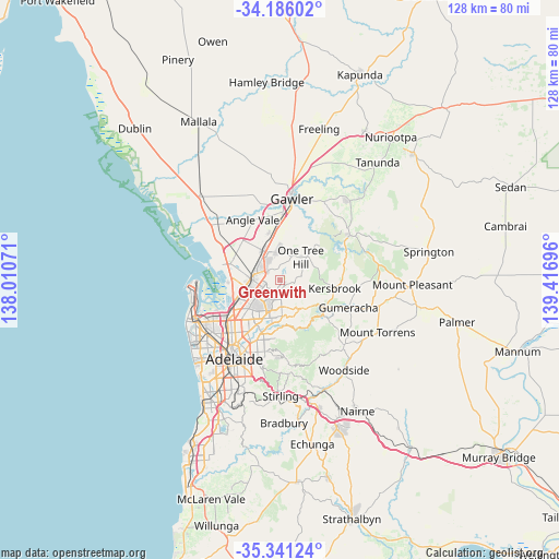
Greenwith GPS coordinates[2]
34° 45' 56.34" South, 138° 42' 49.788" East
| Map corner | latitude | longitude |
|---|---|---|
| Upper-left | -34.18602°, | 138.01071° |
| Center: | -34.76565°, | 138.71383° |
| Lower-right: | -35.34124°, | 139.41696° |
| Map W x H: | 128.4×128.4 km | = 79.8×79.8mi |
| max Lat: | -10.58257° ⇑65.4% North |
| Greenwith: | -34.76565° |
| min Lat: | ⇓34.6% South -43.31423° |
| min Long | Greenwith | max Long |
| 113.53327° | 138.71383° | 153.61246° |
| W 22.1%⇐ | ⇒77.9% E |
Elevation
Elevation of Greenwith is 205 m = 673 ft, and this is 83 m = 272 ft above average elevation for this country.
| Max E: |
1715 m = 5627 ft | 17.9% |
| Greenwith | 205 m 673 ft | |
| Avg. | 122 m = 400 ft | |
Min E: |
-2 m = -7 ft | 82.1% |
See also: Australia elevation on elevation.city.
Geographical zone
Greenwith is located in South temperate zone (between Tropic of Capricorn and the Antarctic Circle). Distance of this Southern Tropic circle is 1259.7 km =782.7 mi to North.| Distance of | km | miles | from Greenwith |
|---|---|---|---|
| Equator | 3865.6 | 2402 | to North |
| Tropic Capricorn | 1259.7 | 782.7 | to North |
| Antarctic Circle | 3535.6 | 2196.9 | to South |
| South Pole | 6141.5 | 3816.1 | to South |


Nearby cities:
15 places around Greenwith: (largest is in red/bold)
• Banksia Park
5.3 km =3.3 mi,  158°
158°
• Elizabeth East
5.4 km =3.4 mi,  327°
327°
• Elizabeth Grove
5.3 km =3.3 mi,  309°
309°
• Elizabeth Vale
4.6 km =2.9 mi,  294°
294°
• Fairview Park
4 km =2.5 mi, 160°
• Golden Grove
2.7 km =1.7 mi,  137°
137°
• Gulfview Heights
5.2 km =3.2 mi,  230°
230°
• Hillbank
4.1 km =2.5 mi,  323°
323°
• Modbury Heights
5.5 km =3.4 mi,  207°
207°
• Redwood Park
5.1 km =3.2 mi,  187°
187°
• Salisbury Heights
3.5 km =2.2 mi,  274°
274°
• Salisbury Park
4 km =2.5 mi,  276°
276°
• Salisbury Plain
4.7 km =2.9 mi,  260°
260°
• Surrey Downs
3.8 km =2.4 mi,  183°
183°
• Wynn Vale
4.5 km =2.8 mi, 212°
Sources, notices
• [Note1] Compared only with cities in Australia existing in our database
• [Src1] Map data: © OpenStreetMap contributors (CC-BY-SA)
• [Src2] Other city data from geonames.org with taken over terms of usage.
• [Src3] Geographical zone / Annual Mean Temperature by Robert A. Rohde @ Wikipedia
