Surrey Downs geodata
Surrey Downs (South Australia) is a section of populated place; located in Australia in Australia/Adelaide (GMT+10.5) time zone. With population of 3,216 people, there are 2118 cities with bigger population in this country. Compared to other cities in Australia, 65.8% of cities are located further ↑North; 78% of cities are located further →East and 80.9% of cities have lower elevation than Surrey Downs. Note1


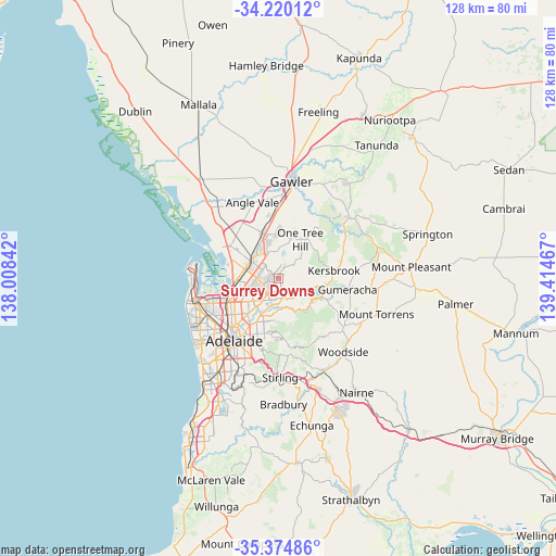
Surrey Downs GPS coordinates[2]
34° 47' 58.236" South, 138° 42' 41.544" East
| Map corner | latitude | longitude |
|---|---|---|
| Upper-left | -34.22012°, | 138.00842° |
| Center: | -34.79951°, | 138.71154° |
| Lower-right: | -35.37486°, | 139.41467° |
| Map W x H: | 128.4×128.4 km | = 79.8×79.8mi |
| max Lat: | -10.58257° ⇑65.8% North |
| Surrey Downs: | -34.79951° |
| min Lat: | ⇓34.2% South -43.31423° |
| min Long | Surrey Downs | max Long |
| 113.53327° | 138.71154° | 153.61246° |
| W 22%⇐ | ⇒78% E |
Elevation
Elevation of Surrey Downs is 192 m = 630 ft, and this is 70 m = 230 ft above average elevation for this country.
| Max E: |
1715 m = 5627 ft | 19.1% |
| Surrey Downs | 192 m 630 ft | |
| Avg. | 122 m = 400 ft | |
Min E: |
-2 m = -7 ft | 80.9% |
See also: Australia elevation on elevation.city.
Geographical zone
Surrey Downs is located in South temperate zone (between Tropic of Capricorn and the Antarctic Circle). Distance of this Southern Tropic circle is 1263.4 km =785 mi to North.| Distance of | km | miles | from Surrey Downs |
|---|---|---|---|
| Equator | 3869.3 | 2404.3 | to North |
| Tropic Capricorn | 1263.4 | 785 | to North |
| Antarctic Circle | 3531.8 | 2194.6 | to South |
| South Pole | 6137.7 | 3813.8 | to South |


Nearby cities:
15 places around Surrey Downs: (largest is in red/bold)
• Banksia Park
2.5 km =1.6 mi,  118°
118°
• Fairview Park
1.6 km =1 mi,  91°
91°
• Golden Grove
2.7 km =1.7 mi,  47°
47°
• Greenwith
3.8 km =2.4 mi,  3°
3°
• Gulfview Heights
3.9 km =2.4 mi,  276°
276°
• Hope Valley
3.9 km =2.4 mi,  195°
195°
• Modbury
4.6 km =2.9 mi,  214°
214°
• Modbury Heights
2.6 km =1.6 mi,  244°
244°
• Modbury North
4.7 km =2.9 mi,  226°
226°
• Redwood Park
1.4 km =0.9 mi, 197°
• Ridgehaven
2.5 km =1.6 mi,  194°
194°
• St Agnes
3.5 km =2.2 mi,  181°
181°
• Tea Tree Gully
2.8 km =1.7 mi,  133°
133°
• Vista
4.1 km =2.5 mi,  165°
165°
• Wynn Vale
2.2 km =1.4 mi,  270°
270°
Sources, notices
• [Note1] Compared only with cities in Australia existing in our database
• [Src1] Map data: © OpenStreetMap contributors (CC-BY-SA)
• [Src2] Other city data from geonames.org with taken over terms of usage.
• [Src3] Geographical zone / Annual Mean Temperature by Robert A. Rohde @ Wikipedia
