Hackney geodata
Hackney (South Australia) is a section of populated place; located in Australia in Australia/Adelaide (GMT+10.5) time zone. With population of 583 people, there are 4615 cities with bigger population in this country. Compared to other cities in Australia, 68.7% of cities are located further ↑North; 80.8% of cities are located further →East and 51.1% of cities have lower elevation than Hackney. Note1


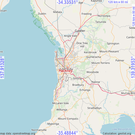
Hackney GPS coordinates[2]
34° 54' 50.04" South, 138° 36' 59.04" East
| Map corner | latitude | longitude |
|---|---|---|
| Upper-left | -34.33531°, | 137.91328° |
| Center: | -34.9139°, | 138.6164° |
| Lower-right: | -35.48844°, | 139.31953° |
| Map W x H: | 128.2×128.2 km | = 79.7×79.7mi |
| max Lat: | -10.58257° ⇑68.7% North |
| Hackney: | -34.9139° |
| min Lat: | ⇓31.3% South -43.31423° |
| min Long | Hackney | max Long |
| 113.53327° | 138.6164° | 153.61246° |
| W 19.2%⇐ | ⇒80.8% E |
Elevation
Elevation of Hackney is 47 m = 154 ft, and this is 75 m = 246 ft below average elevation for this country.
| Max E: |
1715 m = 5627 ft | 48.9% |
| Avg. | 122 m = 400 ft | |
| Hackney | 47 m = 154 ft | |
Min E: |
-2 m = -7 ft | 51.1% |
See also: Australia elevation on elevation.city.
Geographical zone
Hackney is located in South temperate zone (between Tropic of Capricorn and the Antarctic Circle). Distance of this Southern Tropic circle is 1276.1 km =792.9 mi to North.| Distance of | km | miles | from Hackney |
|---|---|---|---|
| Equator | 3882.1 | 2412.2 | to North |
| Tropic Capricorn | 1276.1 | 792.9 | to North |
| Antarctic Circle | 3519.1 | 2186.7 | to South |
| South Pole | 6125 | 3805.9 | to South |


Nearby cities:
15 places around Hackney: (largest is in red/bold)
• Adelaide
2.3 km =1.4 mi,  224°
224°
• Adelaide city centre
2 km =1.2 mi, 215°
• College Park
0.4 km =0.2 mi,  51°
51°
• Evandale
2 km =1.2 mi,  61°
61°
• Gilberton
1.5 km =0.9 mi,  346°
346°
• Joslin
1.8 km =1.1 mi,  30°
30°
• Kent Town
0.9 km =0.6 mi,  158°
158°
• Maylands
1.9 km =1.2 mi,  81°
81°
• Medindie
2.2 km =1.4 mi,  332°
332°
• Norwood
1.9 km =1.2 mi,  143°
143°
• Rose Park
2.1 km =1.3 mi,  149°
149°
• Royston Park
2.3 km =1.4 mi,  37°
37°
• St Peters
1.1 km =0.7 mi, 29°
• Stepney
1.2 km =0.7 mi, 81°
• Trinity Gardens
2.3 km =1.4 mi,  91°
91°
Sources, notices
• [Note1] Compared only with cities in Australia existing in our database
• [Src1] Map data: © OpenStreetMap contributors (CC-BY-SA)
• [Src2] Other city data from geonames.org with taken over terms of usage.
• [Src3] Geographical zone / Annual Mean Temperature by Robert A. Rohde @ Wikipedia
