Joslin geodata
Joslin (South Australia) is a section of populated place; located in Australia in Australia/Adelaide (GMT+10.5) time zone. With population of 1,138 people, there are 3655 cities with bigger population in this country. Compared to other cities in Australia, 68.1% of cities are located further ↑North; 80.5% of cities are located further →East and 51.7% of cities have higher elevation than Joslin. Note1


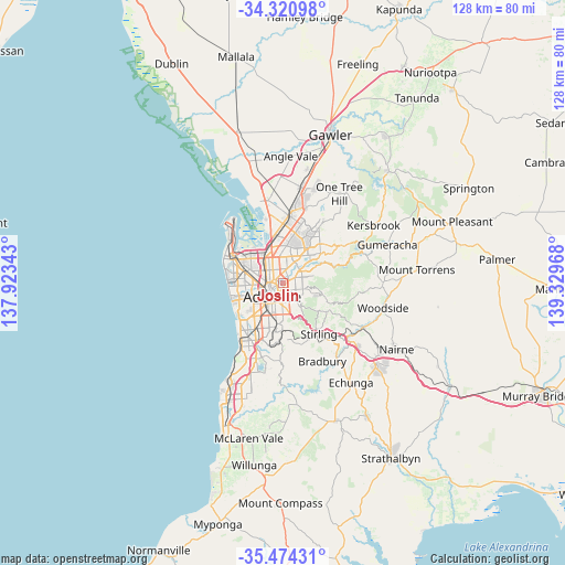
Joslin GPS coordinates[2]
34° 53' 58.812" South, 138° 37' 35.58" East
| Map corner | latitude | longitude |
|---|---|---|
| Upper-left | -34.32098°, | 137.92343° |
| Center: | -34.89967°, | 138.62655° |
| Lower-right: | -35.47431°, | 139.32968° |
| Map W x H: | 128.2×128.2 km | = 79.7×79.7mi |
| max Lat: | -10.58257° ⇑68.1% North |
| Joslin: | -34.89967° |
| min Lat: | ⇓31.9% South -43.31423° |
| min Long | Joslin | max Long |
| 113.53327° | 138.62655° | 153.61246° |
| W 19.5%⇐ | ⇒80.5% E |
Elevation
Elevation of Joslin is 43 m = 141 ft, and this is 79 m = 259 ft below average elevation for this country.
| Max E: |
1715 m = 5627 ft | 51.7% |
| Avg. | 122 m = 400 ft | |
| Joslin | 43 m = 141 ft | |
Min E: |
-2 m = -7 ft | 48.3% |
See also: Australia elevation on elevation.city.
Geographical zone
Joslin is located in South temperate zone (between Tropic of Capricorn and the Antarctic Circle). Distance of this Southern Tropic circle is 1274.6 km =792 mi to North.| Distance of | km | miles | from Joslin |
|---|---|---|---|
| Equator | 3880.5 | 2411.2 | to North |
| Tropic Capricorn | 1274.6 | 792 | to North |
| Antarctic Circle | 3520.7 | 2187.7 | to South |
| South Pole | 6126.6 | 3806.9 | to South |


Nearby cities:
15 places around Joslin: (largest is in red/bold)
• College Park
1.5 km =0.9 mi,  204°
204°
• Collinswood
1.9 km =1.2 mi,  316°
316°
• Evandale
1 km =0.6 mi,  128°
128°
• Gilberton
1.3 km =0.8 mi,  265°
265°
• Hackney
1.8 km =1.1 mi,  210°
210°
• Marden
1.1 km =0.7 mi,  66°
66°
• Maylands
1.6 km =1 mi,  144°
144°
• Medindie
2 km =1.2 mi,  281°
281°
• Payneham
1.3 km =0.8 mi,  78°
78°
• Payneham South
1.7 km =1.1 mi,  109°
109°
• Royston Park
0.5 km =0.3 mi,  62°
62°
• St Peters
0.7 km =0.4 mi, 211°
• Stepney
1.4 km =0.9 mi,  170°
170°
• Trinity Gardens
2.1 km =1.3 mi, 140°
• Vale Park
1.5 km =0.9 mi,  2°
2°
Sources, notices
• [Note1] Compared only with cities in Australia existing in our database
• [Src1] Map data: © OpenStreetMap contributors (CC-BY-SA)
• [Src2] Other city data from geonames.org with taken over terms of usage.
• [Src3] Geographical zone / Annual Mean Temperature by Robert A. Rohde @ Wikipedia
