Doolandella geodata
Doolandella (Queensland) is a section of populated place; located in Australia in Australia/Brisbane (GMT+10) time zone. With population of 4,754 people, there are 1551 cities with bigger population in this country. Compared to other cities in Australia, 79.1% of cities are located further ↓South; 90.7% of cities are located further ←West and 52% of cities have lower elevation than Doolandella. Note1


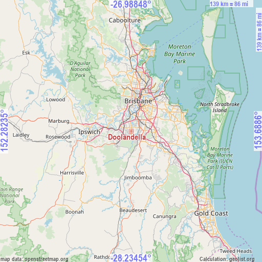
Doolandella GPS coordinates[2]
27° 36' 47.808" South, 152° 59' 7.692" East
| Map corner | latitude | longitude |
|---|---|---|
| Upper-left | -26.98848°, | 152.28235° |
| Center: | -27.61328°, | 152.98547° |
| Lower-right: | -28.23454°, | 153.6886° |
| Map W x H: | 138.5×138.5 km | = 86.1×86.1mi |
| max Lat: | -10.58257° ⇑20.9% North |
| Doolandella: | -27.61328° |
| min Lat: | ⇓79.1% South -43.31423° |
| min Long | Doolandella | max Long |
| 113.53327° | 152.98547° | 153.61246° |
| W 90.7%⇐ | ⇒9.3% E |
Elevation
Elevation of Doolandella is 48 m = 157 ft, and this is 74 m = 243 ft below average elevation for this country.
| Max E: |
1715 m = 5627 ft | 48% |
| Avg. | 122 m = 400 ft | |
| Doolandella | 48 m = 157 ft | |
Min E: |
-2 m = -7 ft | 52% |
See also: Australia elevation on elevation.city.
Geographical zone
Doolandella is located in South temperate zone (between Tropic of Capricorn and the Antarctic Circle). Distance of this Southern Tropic circle is 464.4 km =288.6 mi to North.| Distance of | km | miles | from Doolandella |
|---|---|---|---|
| Equator | 3070.3 | 1907.8 | to North |
| Tropic Capricorn | 464.4 | 288.6 | to North |
| Antarctic Circle | 4330.9 | 2691.1 | to South |
| South Pole | 6936.8 | 4310.3 | to South |


Nearby cities:
15 places around Doolandella: (largest is in red/bold)
• Acacia Ridge
5.8 km =3.6 mi,  54°
54°
• Algester
4.6 km =2.9 mi,  89°
89°
• Archerfield
5.9 km =3.7 mi,  29°
29°
• Calamvale
6.2 km =3.9 mi,  100°
100°
• Darra
6 km =3.7 mi,  328°
328°
• Durack
2.6 km =1.6 mi,  0°
0°
• Ellen Grove
4.1 km =2.5 mi,  266°
266°
• Forest Lake
2.1 km =1.3 mi,  230°
230°
• Forestdale
5.9 km =3.7 mi,  162°
162°
• Heathwood
2.4 km =1.5 mi,  173°
173°
• Inala
2.1 km =1.3 mi, 328°
• Parkinson
5.5 km =3.4 mi,  127°
127°
• Richlands
3.7 km =2.3 mi,  300°
300°
• Sunnybank Hills
6.7 km =4.2 mi, 87°
• Wacol
6.1 km =3.8 mi, 302°
Sources, notices
• [Note1] Compared only with cities in Australia existing in our database
• [Src1] Map data: © OpenStreetMap contributors (CC-BY-SA)
• [Src2] Other city data from geonames.org with taken over terms of usage.
• [Src3] Geographical zone / Annual Mean Temperature by Robert A. Rohde @ Wikipedia
