Bangholme geodata
Bangholme (Victoria) is a section of populated place; located in Australia in Australia/Melbourne (GMT+11) time zone. With population of 770 people, there are 4204 cities with bigger population in this country. Compared to other cities in Australia, 92.2% of cities are located further ↑North; 62.8% of cities are located further →East and 80.4% of cities have higher elevation than Bangholme. Note1


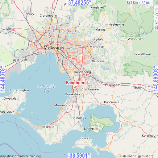
Bangholme GPS coordinates[2]
38° 2' 18.312" South, 145° 11' 12.84" East
| Map corner | latitude | longitude |
|---|---|---|
| Upper-left | -37.48255°, | 144.48378° |
| Center: | -38.03842°, | 145.1869° |
| Lower-right: | -38.5901°, | 145.89003° |
| Map W x H: | 123.1×123.1 km | = 76.5×76.5mi |
| max Lat: | -10.58257° ⇑92.2% North |
| Bangholme: | -38.03842° |
| min Lat: | ⇓7.8% South -43.31423° |
| min Long | Bangholme | max Long |
| 113.53327° | 145.1869° | 153.61246° |
| W 37.2%⇐ | ⇒62.8% E |
Elevation
Elevation of Bangholme is 15 m = 49 ft, and this is 107 m = 351 ft below average elevation for this country.
| Max E: |
1715 m = 5627 ft | 80.4% |
| Avg. | 122 m = 400 ft | |
| Bangholme | 15 m = 49 ft | |
Min E: |
-2 m = -7 ft | 19.6% |
See also: Australia elevation on elevation.city.
Geographical zone
Bangholme is located in South temperate zone (between Tropic of Capricorn and the Antarctic Circle). Distance of this Southern Tropic circle is 1623.6 km =1008.9 mi to North.| Distance of | km | miles | from Bangholme |
|---|---|---|---|
| Equator | 4229.5 | 2628.1 | to North |
| Tropic Capricorn | 1623.6 | 1008.9 | to North |
| Antarctic Circle | 3171.7 | 1970.8 | to South |
| South Pole | 5777.6 | 3590 | to South |


Nearby cities:
15 places around Bangholme: (largest is in red/bold)
• Aspendale Gardens
6.3 km =3.9 mi,  286°
286°
• Bonbeach
6.4 km =4 mi,  241°
241°
• Carrum
6.9 km =4.3 mi,  223°
223°
• Carrum Downs
6.9 km =4.3 mi,  190°
190°
• Chelsea
6.3 km =3.9 mi,  258°
258°
• Chelsea Heights
4.7 km =2.9 mi,  276°
276°
• Dandenong
6.2 km =3.9 mi,  10°
10°
• Doveton
6.8 km =4.2 mi,  42°
42°
• Edithvale
6.8 km =4.2 mi,  271°
271°
• Hampton Park
5.6 km =3.5 mi,  84°
84°
• Keysborough
5.4 km =3.4 mi,  347°
347°
• Lynbrook
6.4 km =4 mi,  107°
107°
• Patterson Lakes
5.1 km =3.2 mi,  228°
228°
• Sandhurst
5.1 km =3.2 mi,  158°
158°
• Waterways
5.6 km =3.5 mi,  298°
298°
Sources, notices
• [Note1] Compared only with cities in Australia existing in our database
• [Src1] Map data: © OpenStreetMap contributors (CC-BY-SA)
• [Src2] Other city data from geonames.org with taken over terms of usage.
• [Src3] Geographical zone / Annual Mean Temperature by Robert A. Rohde @ Wikipedia
