Carramar geodata
Carramar (New South Wales) is a section of populated place; located in Australia in Australia/Sydney (GMT+11) time zone. With population of 3,562 people, there are 1974 cities with bigger population in this country. Compared to other cities in Australia, 55.3% of cities are located further ↑North; 66.8% of cities are located further ←West and 83.5% of cities have higher elevation than Carramar. Note1


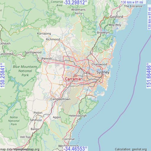
Carramar GPS coordinates[2]
33° 53' 1.752" South, 150° 57' 41.508" East
| Map corner | latitude | longitude |
|---|---|---|
| Upper-left | -33.29812°, | 150.25841° |
| Center: | -33.88382°, | 150.96153° |
| Lower-right: | -34.46553°, | 151.66466° |
| Map W x H: | 129.8×129.8 km | = 80.7×80.7mi |
| max Lat: | -10.58257° ⇑55.3% North |
| Carramar: | -33.88382° |
| min Lat: | ⇓44.7% South -43.31423° |
| min Long | Carramar | max Long |
| 113.53327° | 150.96153° | 153.61246° |
| W 66.8%⇐ | ⇒33.2% E |
Elevation
Elevation of Carramar is 13 m = 43 ft, and this is 109 m = 358 ft below average elevation for this country.
| Max E: |
1715 m = 5627 ft | 83.5% |
| Avg. | 122 m = 400 ft | |
| Carramar | 13 m = 43 ft | |
Min E: |
-2 m = -7 ft | 16.5% |
See also: Australia elevation on elevation.city.
Geographical zone
Carramar is located in South temperate zone (between Tropic of Capricorn and the Antarctic Circle). Distance of this Southern Tropic circle is 1161.6 km =721.8 mi to North.| Distance of | km | miles | from Carramar |
|---|---|---|---|
| Equator | 3767.5 | 2341 | to North |
| Tropic Capricorn | 1161.6 | 721.8 | to North |
| Antarctic Circle | 3633.6 | 2257.8 | to South |
| South Pole | 6239.5 | 3877 | to South |


Nearby cities:
15 places around Carramar: (largest is in red/bold)
• Bass Hill
3.5 km =2.2 mi,  117°
117°
• Cabramatta
2.9 km =1.8 mi,  238°
238°
• Canley Heights
3.5 km =2.2 mi,  272°
272°
• Canley Vale
1.3 km =0.8 mi,  256°
256°
• Chester Hill
3.5 km =2.2 mi,  81°
81°
• Chipping Norton
3.8 km =2.4 mi,  183°
183°
• Fairfield
2.2 km =1.4 mi,  330°
330°
• Fairfield East
1.8 km =1.1 mi,  29°
29°
• Fairfield Heights
3 km =1.9 mi,  315°
315°
• Georges Hall
3.7 km =2.3 mi,  138°
138°
• Guildford West
3.8 km =2.4 mi,  4°
4°
• Lansvale
2.1 km =1.3 mi,  207°
207°
• Old Guildford
3 km =1.9 mi,  43°
43°
• Villawood
1.7 km =1.1 mi,  91°
91°
• Yennora
2.5 km =1.6 mi,  14°
14°
Sources, notices
• [Note1] Compared only with cities in Australia existing in our database
• [Src1] Map data: © OpenStreetMap contributors (CC-BY-SA)
• [Src2] Other city data from geonames.org with taken over terms of usage.
• [Src3] Geographical zone / Annual Mean Temperature by Robert A. Rohde @ Wikipedia
