Lansvale geodata
Lansvale (New South Wales) is a section of populated place; located in Australia in Australia/Sydney (GMT+11) time zone. With population of 2,534 people, there are 2544 cities with bigger population in this country. Compared to other cities in Australia, 56.1% of cities are located further ↑North; 66.7% of cities are located further ←West and 99.1% of cities have higher elevation than Lansvale. Note1


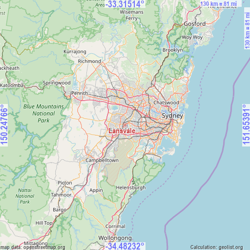
Lansvale GPS coordinates[2]
33° 54' 2.628" South, 150° 57' 2.808" East
| Map corner | latitude | longitude |
|---|---|---|
| Upper-left | -33.31514°, | 150.24766° |
| Center: | -33.90073°, | 150.95078° |
| Lower-right: | -34.48232°, | 151.65391° |
| Map W x H: | 129.8×129.8 km | = 80.7×80.7mi |
| max Lat: | -10.58257° ⇑56.1% North |
| Lansvale: | -33.90073° |
| min Lat: | ⇓43.9% South -43.31423° |
| min Long | Lansvale | max Long |
| 113.53327° | 150.95078° | 153.61246° |
| W 66.7%⇐ | ⇒33.3% E |
Elevation
Elevation of Lansvale is 2 m = 7 ft, and this is 120 m = 394 ft below average elevation for this country.
| Max E: |
1715 m = 5627 ft | 99.1% |
| Avg. | 122 m = 400 ft | |
| Lansvale | 2 m = 7 ft | |
Min E: |
-2 m = -7 ft | 0.9% |
See also: Australia elevation on elevation.city.
Geographical zone
Lansvale is located in South temperate zone (between Tropic of Capricorn and the Antarctic Circle). Distance of this Southern Tropic circle is 1163.5 km =723 mi to North.| Distance of | km | miles | from Lansvale |
|---|---|---|---|
| Equator | 3769.4 | 2342.2 | to North |
| Tropic Capricorn | 1163.5 | 723 | to North |
| Antarctic Circle | 3631.8 | 2256.7 | to South |
| South Pole | 6237.7 | 3875.9 | to South |


Nearby cities:
15 places around Lansvale: (largest is in red/bold)
• Bass Hill
4.1 km =2.5 mi,  86°
86°
• Cabramatta
1.6 km =1 mi,  283°
283°
• Cabramatta West
3.7 km =2.3 mi, 283°
• Canley Heights
3.2 km =2 mi,  309°
309°
• Canley Vale
1.6 km =1 mi,  350°
350°
• Carramar
2.1 km =1.3 mi,  27°
27°
• Chipping Norton
2.1 km =1.3 mi,  157°
157°
• Fairfield
3.8 km =2.4 mi,  358°
358°
• Fairfield East
4 km =2.5 mi, 28°
• Fairfield Heights
4.2 km =2.6 mi,  344°
344°
• Georges Hall
3.6 km =2.2 mi,  104°
104°
• Liverpool
3.1 km =1.9 mi,  227°
227°
• Mount Pritchard
4.3 km =2.7 mi,  266°
266°
• Villawood
3.3 km =2.1 mi,  56°
56°
• Warwick Farm
1.9 km =1.2 mi,  223°
223°
Sources, notices
• [Note1] Compared only with cities in Australia existing in our database
• [Src1] Map data: © OpenStreetMap contributors (CC-BY-SA)
• [Src2] Other city data from geonames.org with taken over terms of usage.
• [Src3] Geographical zone / Annual Mean Temperature by Robert A. Rohde @ Wikipedia
