Erindale geodata
Erindale (South Australia) is a section of populated place; located in Australia in Australia/Adelaide (GMT+10.5) time zone. With population of 1,163 people, there are 3624 cities with bigger population in this country. Compared to other cities in Australia, 69.2% of cities are located further ↑North; 79.1% of cities are located further →East and 75.2% of cities have lower elevation than Erindale. Note1


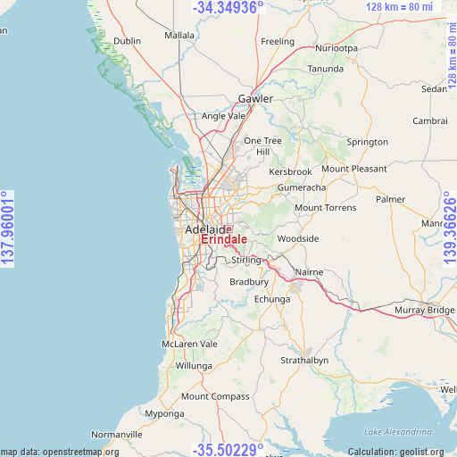
Erindale GPS coordinates[2]
34° 55' 40.26" South, 138° 39' 47.268" East
| Map corner | latitude | longitude |
|---|---|---|
| Upper-left | -34.34936°, | 137.96001° |
| Center: | -34.92785°, | 138.66313° |
| Lower-right: | -35.50229°, | 139.36626° |
| Map W x H: | 128.2×128.2 km | = 79.7×79.7mi |
| max Lat: | -10.58257° ⇑69.2% North |
| Erindale: | -34.92785° |
| min Lat: | ⇓30.8% South -43.31423° |
| min Long | Erindale | max Long |
| 113.53327° | 138.66313° | 153.61246° |
| W 20.9%⇐ | ⇒79.1% E |
Elevation
Elevation of Erindale is 133 m = 436 ft, and this is 11 m = 36 ft above average elevation for this country.
| Max E: |
1715 m = 5627 ft | 24.8% |
| Erindale | 133 m 436 ft | |
| Avg. | 122 m = 400 ft | |
Min E: |
-2 m = -7 ft | 75.2% |
See also: Australia elevation on elevation.city.
Geographical zone
Erindale is located in South temperate zone (between Tropic of Capricorn and the Antarctic Circle). Distance of this Southern Tropic circle is 1277.7 km =793.9 mi to North.| Distance of | km | miles | from Erindale |
|---|---|---|---|
| Equator | 3883.6 | 2413.2 | to North |
| Tropic Capricorn | 1277.7 | 793.9 | to North |
| Antarctic Circle | 3517.6 | 2185.7 | to South |
| South Pole | 6123.4 | 3804.9 | to South |


Nearby cities:
15 places around Erindale: (largest is in red/bold)
• Auldana
2.4 km =1.5 mi,  63°
63°
• Beulah Park
2 km =1.2 mi,  304°
304°
• Hazelwood Park
1.4 km =0.9 mi,  197°
197°
• Heathpool
1.6 km =1 mi,  255°
255°
• Kensington Gardens
0.3 km =0.2 mi,  325°
325°
• Kensington Park
1.2 km =0.7 mi,  316°
316°
• Leabrook
0.5 km =0.3 mi,  242°
242°
• Linden Park
2.3 km =1.4 mi,  219°
219°
• Magill
2.3 km =1.4 mi,  27°
27°
• Marryatville
1.6 km =1 mi,  267°
267°
• Rosslyn Park
1.3 km =0.8 mi, 59°
• St Morris
2.1 km =1.3 mi,  335°
335°
• Stonyfell
1.4 km =0.9 mi,  119°
119°
• Tusmore
1.7 km =1.1 mi, 222°
• Wattle Park
1.1 km =0.7 mi,  74°
74°
Sources, notices
• [Note1] Compared only with cities in Australia existing in our database
• [Src1] Map data: © OpenStreetMap contributors (CC-BY-SA)
• [Src2] Other city data from geonames.org with taken over terms of usage.
• [Src3] Geographical zone / Annual Mean Temperature by Robert A. Rohde @ Wikipedia
