Haynes geodata
Haynes (Western Australia) is a section of populated place; located in Australia in Australia/Perth (GMT+8) time zone. With population of 733 people, there are 4274 cities with bigger population in this country. Compared to other cities in Australia, 63% of cities are located further ↓South; 92.7% of cities are located further →East and 61.8% of cities have higher elevation than Haynes. Note1


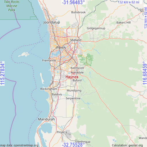
Haynes GPS coordinates[2]
32° 9' 43.2" South, 115° 58' 53.256" East
| Map corner | latitude | longitude |
|---|---|---|
| Upper-left | -31.56483°, | 115.27834° |
| Center: | -32.162°, | 115.98146° |
| Lower-right: | -32.75528°, | 116.68459° |
| Map W x H: | 132.4×132.4 km | = 82.3×82.3mi |
| max Lat: | -10.58257° ⇑37% North |
| Haynes: | -32.162° |
| min Lat: | ⇓63% South -43.31423° |
| min Long | Haynes | max Long |
| 113.53327° | 115.98146° | 153.61246° |
| W 7.3%⇐ | ⇒92.7% E |
Elevation
Elevation of Haynes is 30 m = 98 ft, and this is 92 m = 302 ft below average elevation for this country.
| Max E: |
1715 m = 5627 ft | 61.8% |
| Avg. | 122 m = 400 ft | |
| Haynes | 30 m = 98 ft | |
Min E: |
-2 m = -7 ft | 38.2% |
See also: Australia elevation on elevation.city.
Geographical zone
Haynes is located in South temperate zone (between Tropic of Capricorn and the Antarctic Circle). Distance of this Southern Tropic circle is 970.2 km =602.9 mi to North.| Distance of | km | miles | from Haynes |
|---|---|---|---|
| Equator | 3576.1 | 2222.1 | to North |
| Tropic Capricorn | 970.2 | 602.9 | to North |
| Antarctic Circle | 3825.1 | 2376.8 | to South |
| South Pole | 6431 | 3996 | to South |


Nearby cities:
15 places around Haynes: (largest is in red/bold)
• Armadale
3.2 km =2 mi,  55°
55°
• Bedfordale
6.6 km =4.1 mi,  101°
101°
• Brookdale
2 km =1.2 mi,  105°
105°
• Camillo
5.8 km =3.6 mi,  19°
19°
• Champion Lakes
4.8 km =3 mi,  5°
5°
• Darling Downs
3.7 km =2.3 mi,  164°
164°
• Forrestdale
4.5 km =2.8 mi,  279°
279°
• Hilbert
1.8 km =1.1 mi,  169°
169°
• Kelmscott
5.9 km =3.7 mi,  44°
44°
• Mount Nasura
4.9 km =3 mi, 56°
• Mount Richon
4 km =2.5 mi, 108°
• Oakford
6.2 km =3.9 mi,  225°
225°
• Piara Waters
6.9 km =4.3 mi,  297°
297°
• Seville Grove
2.9 km =1.8 mi, 14°
• Southern River
6.5 km =4 mi,  341°
341°
Sources, notices
• [Note1] Compared only with cities in Australia existing in our database
• [Src1] Map data: © OpenStreetMap contributors (CC-BY-SA)
• [Src2] Other city data from geonames.org with taken over terms of usage.
• [Src3] Geographical zone / Annual Mean Temperature by Robert A. Rohde @ Wikipedia
